
Measuring
!
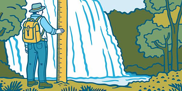
If there is anything about a waterfall that should be taken with a grain of salt, it’s the stated height. So many things must come together for a height measurement to be accurate, and for most measurements given for North Carolina waterfalls, these factors aren’t present.
The first issue that must be addressed with any method of measurement is where to start and end the calculation. Waterfallers in the Cumberland Plateau region of Tennessee have it easy, as a lot of their waterfalls have a top and bottom that can be objectively identified.
Not so in North Carolina. Very few of our waterfalls have a starting and stopping point that most would agree on. Do you include cascades or slides above and below the main drop? If several main drops are separated by short distances of flatter water, do you include all the drops as single measurement, or do you list them individually. If separate, how much space must be between them, and how flat does the water have to be?
These questions can’t always be answered. There is even debate with some waterfalls that most people would never question. For example, there is more than one North Carolina waterfall that has a long continuous descent that someone has decided should be referred to as two separate waterfalls. I don’t recognize these names. See the Classifying page for more about this issue.
One objective (for most people) aspect of determining the height of a waterfall is that the measurement should be of the elevation difference, not the length of run.
There are many different methods for measuring waterfall heights, each with pros and cons. Here are some of them.
Using altitude measurements
The idea is simple: Measure the altitude and the top and bottom of the waterfall, then subtract the bottom measurement from the top to get the height. What could be easier and more accurate? Every other method listed here, is what.
The first issue is one that all methods face. Where do you start and stop the measurements. But even more relative is the fact that you can’t get a precise altitude measurement to begin with. That app on your phone is simply not accurate enough for precise measurements. If the waterfall is several hundred feet high, being off by a few feet won’t be a big problem, but if the waterfall is only 15 feet high, well.
Estimating on site
For the first three editions of my North Carolina waterfall book I measured most waterfalls by guessing. Depending on the nature of the waterfall and the vantage point, my guesses ranged from very close to embarrassingly off, and this is going to be the case with anyone. Any measurements made by this method should only be used for comparisons and a general idea.
For shorter waterfalls, guessing at the height might be a fairly accurate method, but for the taller falls it can be far off. Typically, when you stand at the base of a falls and tilt your head up, the waterfall tends to look shorter than it really is. Conversely, when you stand at the top of falls and look down, it appears higher. For the best accuracy, you would view the waterfall from a point midway on the falls and not tilt your head up or down. How many waterfalls let you do that?
The other issue with guessing is that most people are just not good at it. When I’ve been with other people at waterfalls and asked each of them to estimate the height, the results varied widely. I used to think I was fairly good at estimating heights, and still do to some extent, but now that I’m using an electronic rangefinder I’m finding that some of my old estimates are way off.
Counting contour lines on topo maps
This method is fairly accurate for very high waterfalls but can be very inaccurate for those less than several hundred feet high. And it’s basically useless for waterfalls less than 50 feet or so high. A big problem with the smaller waterfalls is that it’s often impossible to know where start and end counting the lines. Another issue is that the standard USGS topo maps are simply not accurate enough to use for determining shorter heights. A 30-foot waterfall can completely hide within the 40-foot contours used on most western North Carolina USGS topo maps.
LiDAR
Light Detection and Ranging technology has revolutionized contour mapping. Unlike the standard 40-foot contours for most topo maps in western North Carolina, LiDAR can have accuracy measured in inches.
LiDAR would seem to be the ideal method for determining a waterfall’s height, but it has the same drawback as counting lines on a topo map: where to start and stop counting. That said, LiDAR is the best method for measuring waterfalls that have multiple drops, where you can’t see the top of the uppermost drop and bottom of the lowest drop from a single vantage point.
Dropping a line over the falls
Interestingly, this primitive method for measuring height is the most accurate provided two important factors are present. First, the line can’t stretch. Second, the waterfall must be a freefall. If it’s not, you’ll end up measuring the length of run and not the height.
Of course, as with all methods, this one is still reliant on choosing a starting and stopping point. So, if there are drops above or below the main free-falling section, you’ll only be able to achieve a dead accurate measurement for part of the falls.
Another thing to consider is that the only people who should ever consider measuring a waterfall like this are those who are well trained in using ropes so they can safely position themselves at the brink of the falls.
Manual measurements using trigonometry
Remember all those formulas from your high school trig and geometry classes? Me neither. Basically, if you know the distance from you to the top of the waterfall, and the angle of that line relative to the line of sight to the bottom of the waterfall, you can use trigonometry to calculate the height.
The length to the top can be determined using a rangefinder. The angle can be determined using a clinometer.
If the measurements are done accurately, the final height measurement will be accurate. But, and this is a big but, this method involves a lot of time and precision with the measurements and calculations. And, once again, you face the issue of determining the starting and stopping points.
A bunch of other methods involving sticks, body parts, or a lot of math
Search how to measure the height of tree and you’ll find all sorts of methods not listed here. Foresters use special rulers called Biltmore Sticks. There are methods for using your hands or arms for estimating heights. Using trigonometry again, you can determine the height of a waterfall regardless of your viewing position.
Even the body part methods are relatively accurate, but I don’t consider any of these methods particularly useful for North Carolina waterfalls, because, again, very few of them have an objective top and bottom. Furthermore, a lot of them do not allow you to see both the top and bottom from the same vantage point.
How I measure waterfalls
Up until 2022, I estimated the height in the field for most measurements. If that wasn’t possible, such as when I couldn’t see the top and/or bottom of the falls to make a guess, I simply didn’t get a measurement and stated a broad estimate. For high falls, I sometimes counted contour lines on topo maps.
In 2022, I started using the Nikon Forestry Pro II Rangefinder and it has dramatically improved my measurements. The first time I used it I seriously questioned my sanity for not buying one of these guys long ago. I also use LiDAR for some of the waterfalls that don’t allow measurements using the rangefinder.
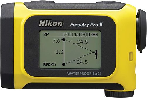
This little guy has greatly improved my waterfall measuring.
The Nikon rangefinder has a built-in clinometer, so all I need to do is take a reading at the top and bottom of the waterfall and the unit automatically calculates the height. The really cool thing is that you do not need to measure from the bottom of the falls. You can get an accurate reading from the side or even the top of a waterfall. For example, I measured one waterfall while standing on the road bridge above since it’s on private property with a house beside it and I didn’t want to go down to the base. I simply took a reading down to the top and then the base and the rangefinder calculated the height.
It’s extremely accurate, but like all waterfall measuring methods, it has drawbacks. The biggest issue is the one that applies to all methods, which is where to start and stop the measurement. But the reading you get from the two points you do choose will be accurate, so it’s by far the best method to use in the field.
Okay, I should expand and clarify that last statement. The rangefinder is accurate, but it comes with a learning curve on how to make sure you are using it properly to get the reading you want. I discovered this very quickly when I took several readings at a waterfall and got different results.
Since the device is only a few inches long, the slightest hand movement will cause the target dot to dance wildly, especially the farther away the waterfall is. If there are tree branches close by, you could easily get a reading from a branch and not realize it. When I can’t get a good lock on a target, I brace the unit on my tripod, which helps greatly.
I discovered another issue after just about losing my mind at Bird Rock Falls. Attempting to measure the height of the cliff overhanging the falls, I kept getting readings that I knew were way off. I thought the rangefinder was defective. But I kept measuring and finally discovered what was going on. There was quite a bit of spray from the waterfall and that dang rangefinder is so accurate it was reading the moisture droplets from the spray instead of what I was aiming at! I had this happen at other waterfalls as well. So, I’ve now learned that I can’t use the rangefinder when shotting through spray or rain.
Another drawback is that this device will not measure anything that is closer than about 30 feet away, so this eliminates a lot of waterfalls where you can’t back up very far.
Even with these limitations, the rangefinder is the most practical and accurate method for measuring waterfalls where you can see both the top and the bottom of the falls from one vantage point.