
Beetree Fork Falls
!
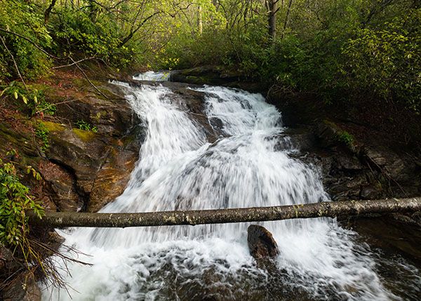
Beetree Fork Falls is very close to the road, but getting a good view of it is not easy. I’ve known about this waterfall and its upstream neighbor since my earliest waterfalling days, but only in the early 2020s did I take the time to climb down the bank and get a closeup view of them. Should have done it sooner. If the water flow and lighting are good, you’ll make some nice photos, but be sure to heed the cautions under Special Considerations.
(022L-213236)
Driving Directions
Open driving directions in map appFrom Beech Gap on Blue Ridge Parkway, drive about 6 miles south on NC 215 and park on the right at the start of FS 5030. This is 0.3 miles from the falls, but there’s nowhere to park near the falls so you must walk along the road.
The waterfall is 0.3 miles north of FS 140, so you could park in the area beside NC 215 across from FS 140 and walk north along NC 215 to the falls. FS 140 is about 6.65 miles south of Blue Ridge Parkway and 10.4 miles north of US 64.
If you’re accessing the falls by wading North Fork French Broad River, drive about a quarter mile on FS 140, where you can see the falls across river.
If you’re also visiting Upper Beetree Fork Falls, parking at the start of FS 140 will add 0.2 miles of road walking. If you’re only seeing Beetree Fork Falls, the road distance will be the same regardless of where you park.
Hiking Directions
Quick Glance
If parking at FS 5030, Walk 0.3 miles south along the road and climb down bank.
Detailed Look
If parking beside NC 215, walk south from FS 5030 or north from FS 140. At 0.3 miles you’ll hear and see the falls from the road. Climb down bank to base.
Upper Beetree Fork Falls is 0.1 miles upstream and also very close to the road.
| Accessibility: | Bank scramble and road walk |
| County: | Transylvania |
| River Basin: | French Broad |
| Watercourse: | Beetree Fork |
| Watershed: | Small |
| Type and Height: | Cascading falls about 25 feet high Height measured with rangefinder. |
| Landowner: | Pisgah NF, Pisgah RD |
| Beauty Rating: | 4 |
| Elevation: | 3000 feet |
| USGS Map: | Sam Knob |
| Hike Difficulty: | Difficult |
| Hike Distance: | Short bank scramble plus 0.3-mile road walk |
| Waterfall GPS: | 35.251294, -82.890552 |
| Trailhead GPS 1 & 2: | 35.253501, -82.894334 This is for the upper trailhead at FS 5030. This is for the lower trailhead at FS 140. |