
Bent Fields Falls
!
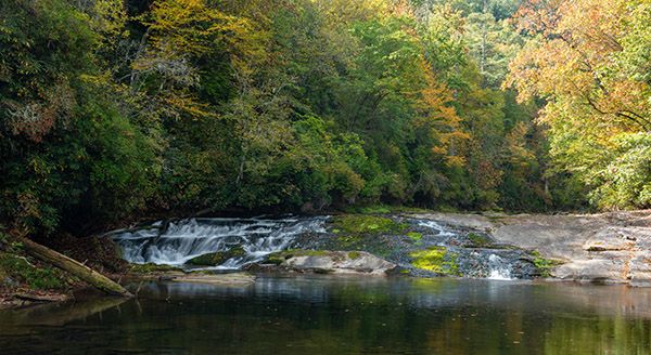
Here’s one you can safely dismiss unless you need to cross it off a list you’re working on. Not that it’s all that unremarkable, but there are better places nearby to burn your energy, especially considering that to see this falls you must spend some waist time in the river.
(06E-25285)
Driving Directions
Open driving directions in map appIf coming from US 64, near Rosman, drive 4.6 miles north on NC 215 and park in the pullout on the left. If coming from Blue Ridge Parkway, drive 12.5 miles south on NC 215 and park in the pullout on the right.
Hiking Directions
Quick Glance
Follow the obvious path down to the river, walk upstream a short distance, cross river, follow the obvious path to reach the river again farther upstream, then wade the river upstream to the falls.
Detailed Look
An obvious path leads from the pullout. In a short distance, you’ll pick up an old roadbed as it swings around the broad ridge. Turn left and descend steeply to the river. The trail is obvious the entire way.
Once at the river, head upstream about 50 yards, passing through a campsite, to a side stream. Cross French Broad River here, which is an easy wade at normal and low water levels.
Climb up the bank on the other side of the river and follow the path that leads upstream under the power line. In a quarter mile, you’ll reach the river again. From here, the river is the trail, although you may get on the bank for a short distance. It’s about a quarter mile upstream to the falls. With normal flow, it’s a fairly easy wade if you’re very careful, but don’t expect to keep your belt dry. If the water is up at all, turn around.
| Accessibility: | Hiking trail and river wade |
| County: | Transylvania |
| River Basin: | French Broad |
| Watercourse: | North Fork French Broad River |
| Watershed: | Medium/large |
| Type and Height: | River-wide, 10-foot sliding cascade Height measured with rangefinder. |
| Landowner: | Pisgah NF, Pisgah RD |
| Beauty Rating: | 3 |
| Elevation: | 2560 feet |
| USGS Map: | Rosman |
| Hike Difficulty: | Difficult Requires a long, deep river wade |
| Hike Distance: | Approx. 0.6 miles |
| Waterfall GPS: | 35.192326, -82.853868 Reading taken from the downstream end of the large pool. |
| Trailhead GPS: | 35.190183, -84.848272 |