
Big Bearwallow Falls
!
A nice falls enveloped in a not so pleasant environment. Sadly, the road banks along this section of Big Bearwallow Creek have been used as a local garbage dump. You’ll walk through a bunch of it on the way down to the falls. And when you get there, unless things have changed since my last visit, you’ll be surrounded by a lot of fallen trees all over the waterfall and the slopes around it.
It’s a shame, as Big Bearwallow Falls is an otherwise scenic waterfall, as evidenced in the photo I took several years ago. Hopefully, things will have improved on your visit.
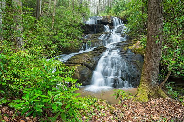
I made this image in 2014. On a recent visit, the hemlock tree on the right was snapped off and there were fallen trees all over the place. (006G-100353)
Driving Directions
Open driving directions in map appFrom US 64 near Rosman, drive 2.6 miles north on NC 215 and park in the pullout on the left (west) side. This is 14.45 miles south of the Blue Ridge Parkway.
Hiking Directions
Quick Glance
Descend the steep path a few hundred feet, then swing to the right and scramble upstream to the falls.
Detailed Look
The path begins from the middle of the pullout, a few feet to the right of a large maple tree that has poison ivy vines on it. Descend very steeply to a junction where you need to turn right and immediately pass by a small cliff. The path is not easy to follow from this point, but if you stay on the route of least resistance you should be okay.
| Accessibility: | Scramble path |
| County: | Transylvania |
| River Basin: | French Broad |
| Watercourse: | Big Bearwallow Creek |
| Watershed: | Small |
| Type and Height: | Steep, cascading falls about 35 feet high Height estimated. |
| Landowner: | Pisgah NF, Pisgah RD |
| Beauty Rating: | 5 |
| Elevation: | 2420 feet |
| USGS Map: | Rosman |
| Hike Difficulty: | Difficult |
| Hike Distance: | Less than 0.1 miles |
| Waterfall GPS: | 35.170533, -82.84189 |
| Trailhead GPS: | 35.169691, -82.841798 |