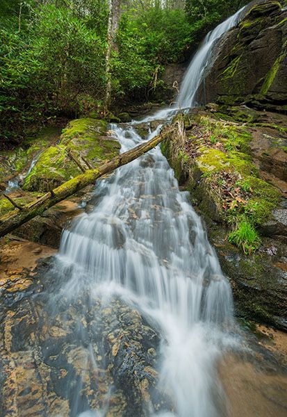
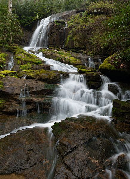
Case Falls
!
This is a pretty little falls that’s fairly easy to reach as bushwhacks go. Rhododendron drapes the banks and lush moss covers everything, creating a rain-forest feel.
With that said, I haven’t been back since Tropical Storm Helene came through in 2024. The storm severely impacted the area, especially the Hungry River corridor just downstream from Case Falls.
(002L-212534)
Driving Directions
Open driving directions in map appThe trailhead is the same for Case Falls, Briefcase Falls, Lower Briefcase Falls, and Lower Falls on Hungry River.
Southeast of Hendersonville, take Exit 53 off I-26 onto Upward Road. Head east (away from Hendersonville) on Upward Road for 1.6 miles and turn right on Big Hungry Road (SR 1802). The road forks at 0.5 miles; stay left to remain on Big Hungry Road. Continue 0.25 miles to another fork and bear right. From this fork, drive 0.5 miles and turn right on Gallimore Road (SR 1956). Drive 0.6 miles to the parking area at the end of the road.
The road ends at a turnaround, with room to park along the outside of the curve. The large, gated parking area in the field is for kayakers accessing Green River. As far as I can determine, kayakers aren’t allowed to park in the turnaround, but it’s okay for hikers. To be safe, you can leave a note on your dash with “hiker” written on it.
Hiking Directions
I’m including directions for Case Falls, Briefcase Falls, and Lower Briefcase Falls since they are so close together.
Quick Glance
Hike the old road directly opposite the kayaker parking lot for 100 yards and turn right on the faint side path that’s in the outside of a left-hand curve. The side path descends to Case Falls. To see the two falls downstream, break off the path to Case Falls at the easiest spot. Avoid getting too close to the creek until you’re ready to descend to the base of each falls.
Detailed Look
Face the turnaround with the kayaker parking to the right. Enter the woods on the left, on the old gated road. (A small creek flows under the turnaround. Do not cross it and do not take the road at the end of the turnaround.) After about 100 yards, you’ll swing left around a curve. A faint side path turns right, in the outside of the curve. The path descends steeply to the base of Case Falls.
Briefcase Falls is a short distance downstream. There’s no trail, but you might pick up a faint path. The best route is to turn off the path leading to Case Falls before you reach the rhododendron and nastiness near the creek, then just follow the route of least resistance as you swing around and down. As you get close to the falls, you should pick up a noticeable path.
Lower Briefcase Falls is only a few yards downstream from Briefcase Falls, but there’s no good way to reach it near the creek. Best bet is to climb back up and swing around by following the route of least resistance.
| Accessibility: | Hiking trail and ungraded path |
| County: | Henderson |
| River Basin: | Broad |
| Watercourse: | Tributary of Hungry River |
| Watershed: | Very small |
| Type and Height: | Freefall and cascades about 35 feet high Height estimated. |
| Landowner: | Green River Game Land |
| Beauty Rating: | 6 |
| Elevation: | 1760 feet |
| USGS Map: | Cliffield Mountain |
| Hike Difficulty: | Difficult |
| Hike Distance: | About 200 yards |
| Waterfall GPS: | 35.288686, -82.359215 |
| Trailhead GPS: | 35.29019, -82.35955 |
Photo Gallery
Click a photo to enlarge.