
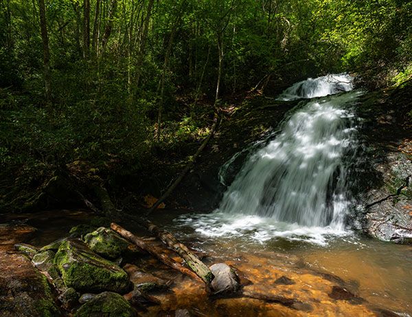
Clear Creek Falls
!
Clear Creek Falls is among a small number of waterfalls that make good destinations for a boat trip, in this case from Nantahala Lake. It doesn’t fall directly into the lake (I know of only about 15 waterfalls in North Carolina that do that), but a short hike from the lake takes you to it.
My first trip to the falls was by kayak. Later, I was checking out some areas of the national forest upstream from the falls when a local landowner told me about accessing it from above. I couldn't check it out at that time and didn't go back until a few years later after a friend hiked to it that way and said it was a good route.
I’m providing information for the land access route, but my favorite way to see the falls remains the lake access. Nantahala Lake is wonderful for a kayaking or canoeing adventure.
(072N-168739)
Driving Directions
Open driving directions in map appFrom downtown Hayesville, get on Tusquitee Road (SR 1307) and drive 10.3 miles to the end of the pavement. Continue on the dirt road. If you have a high-clearance vehicle, you can make it without four-wheel drive, but there are a few spots where you’ll probably wish you had it. Do not attempt this road in a low-clearance vehicle.
At 3.25 miles from the end of the pavement, you’ll ford Clear Creek, which isn’t a problem unless it’s right after heavy rains. A short distance farther, you’ll come to a surprising open area with an old house and several RV’s scattered about. Just beyond that, you’ll ford another, much smaller stream. A quarter mile from the ford is the trailhead. Look for a gated road cutting back to the right, just before a tiny branch crossing the road. On the left is a parking space for a single vehicle.
Hiking Directions
Quick Glance
Nothing quick here!
Detailed Look
Start on the old road beyond the gate and cross Stephens Branch in 40 feet. You’ll soon meet up with Clear Creek and follow it down to the falls, sometimes close, sometimes out of earshot. After about 0.5 miles, you’ll reach an open field on the right, while the road you’ve been following goes left. Walk through the field. You should be able to follow a path that skirts it on the left side.
You’ll reenter the woods in about 180 yards. At this point it may be a little difficult to discern the route. Walk a short distance to an open area with a campsite, then swing to the left. There is a path of sorts that you should be able to follow if you look closely. In a short distance you’ll connect with another old road. Follow this road to a junction where the road makes a sharp swing to the left, while a path cuts off to the right. This junction is less than 0.2 miles from the field. You can easily hear Clear Creek from this point.
Take the path toward the creek. You’ll pass close by a small waterfall, then continue downstream to Clear Creek Falls. Getting to this point is a piece of cake, but the descent to the base is very steep.
Lake Access
I highly recommend using a map app on your phone to help you navigate the lake and find the Clear Creek cove. From the lake, a path on river right goes a little over 0.1 miles to the falls.
| Accessibility: | Hiking trail |
| County: | Clay |
| River Basin: | Little Tennessee |
| Watercourse: | Clear Creek |
| Watershed: | Small |
| Type and Height: | Two-level steep cascade, about 35 feet high Height estimated. |
| Landowner: | Nantahala NF, Tusquitee RD |
| Beauty Rating: | 5 |
| Elevation: | 3100 feet |
| USGS Map: | Topton |
| Hike Difficulty: | Moderate/difficult |
| Hike Distance: | 0.8 miles |
| Waterfall GPS: | 35.1513, -83.658188 |
| Trailhead GPS: | 35.14608, -83.66787 |