
Climbing Wall Falls
!
This is a good spot for anyone who likes their rock cliffs a little damp. If you’re hoping for a waterfall, though, you’ll want to visit during a heavy rain. I made the photo on this page after a stretch of very wet weather, and even then only a trickle was spilling over the falls.
Another challenge is getting there. You must first cross Looking Glass Creek, and if there’s enough water to make the falls look good, that crossing may be difficult. Once you’re across, you’ll have a tough climb up the branch to reach the waterfall.
Even so, Climbing Wall Falls is surprisingly attractive for this kind of waterfall, and the hike is short. Experienced bushwhackers may find it worthwhile when the water level is right.
You can glimpse Climbing Wall Falls from the trailhead. In summer, foliage hides the view, but in winter you can see the upper portion through the trees. In freezing weather, the icicles hanging from the top of the falls are fairly easy to spot.
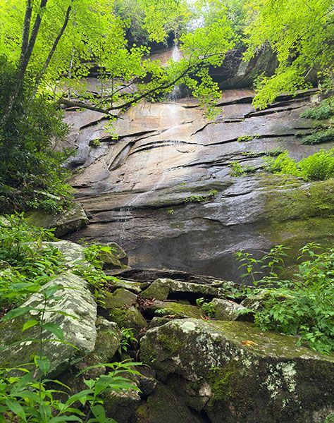
Climbing Wall Falls after moderate rain. (065S-274068)
Driving Directions
Open driving directions in map appThe trailhead is the same as Looking Glass Creek F3.
Four pullouts, close together, are on the creek side of US 276 at Looking Glass Creek F3. The pullout farthest south (downstream) is 7.7 miles south of Blue Ridge Parkway and 7.5 miles north of the junction with NC 280/US 64. This is the one you want.
Hiking Directions
Quick Glance
Scramble down the bank to the falls on Looking Glass Creek, continue downstream to the stream entering from the opposite side, then follow that stream up to the waterfall.
Detailed Look
A scramble path descends to the base of Looking Glass Creek F3. From there, follow the creek downstream about 150 feet to the small stream entering on the other side. Look closely, as it’s easy to miss. Cross Looking Glass Creek and follow this stream upstream. You’ll probably want to stay in the creek for most of the way.
| Accessibility: | Class III Bushwhack |
| County: | Transylvania |
| River Basin: | French Broad |
| Watercourse: | Tributary of Looking Glass Creek |
| Watershed: | Itsy bitsy |
| Type and Height: | 100-foot freefalling and sliding falls over massive rock face Height measured with rangefinder. |
| Landowner: | Pisgah NF, Pisgah RD |
| Beauty Rating: | 3 |
| Elevation: | 2840 feet |
| USGS Map: | Shining Rock |
| Hike Difficulty: | Difficult Class III bushwhack |
| Hike Distance: | A little over 0.1 mile |
| Waterfall GPS: | 35.305619, -82.783375 |
| Trailhead GPS: | 35.306375, -82.782696 |