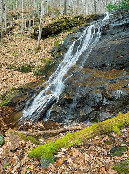
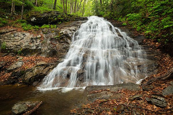
Falling Water Branch Falls
!
Mount Mitchell State Park turned 100 years old in 2016. It couldn’t have received a better birthday present than to double in size. The Conservation Fund announced in 2016 that it was acquiring two tracts of land totaling over 2,700 acres on the western slopes of the Black Range and would transfer the property to the state park, which it did in 2019.
On one of the new tracts is Cattail Peak along the crest of the Black Mountains. At about 6,584 feet (only 100 feet lower than Mount Mitchell), it was the highest privately owned mountain in the East before the park acquired it.
The new land also includes nearly the entire watershed of Falling Water Branch. The small stream tumbles through a scenic and mostly open forest that provides excellent wildflower habitat. Falling Water Branch Falls is the highlight of the forest.
As of now, access to the falls is only suited for hard-core waterfallers. Hopefully, the state park will construct a trail to the falls.
(070T-270300)
Driving Directions
Open driving directions in map appFrom US 19E in Burnsville, get on NC 197 heading south and set your odometer to 0. In the community of Murchison, NC 197 turns right and crosses Cane River. Don’t turn right. Continue straight on what is now Ewart Wilson Road. In about 12.2 miles from US 19E, you’ll reach an old, gated road on the left. Park here.
Less than 0.1 mile before the trailhead is Waterfall 1 on tributary to Cane River.
Hiking Directions
Quick Glance
Follow old road to open field, angle left across field to pick up old logging/mining grade that ascends to creek, then work your way upstream by route of least resistance.
Detailed Look
A lot has changed since my 2017 visit. Some of the logging (mining?) grades I followed no longer exist or aren’t good options. I believe the route I’m giving here is now the best way to reach the falls, but I can’t say for certain.
Follow the old road from the gate. In 200 feet you’ll come to a field under a powerline. You want to cross the field on an angle to the left and pick up an old road entering the woods. GPS for this point is 35.806083, -82.313633.
In about 0.1 mile, another old road turns right. Continue straight. In another tenth of a mile the road reaches Falling Water Branch. About 100 feet before the creek is another road that ascends alongside the creek. It’s narrow, overgrown, and steep, but it provides the route of least resistance.
Follow the grade up to another old road that goes down to the creek. Don’t turn right on it and go to the creek. You want to cross it instead and continue following the grade that runs parallel to the creek. This section is very steep. The grade reaches a clear view of main lower section of the falls and continues up to the upper part.
I don’t recommend hiking to the upper section. To reach the lower drop, you must climb down the slope from the old road. Be extremely careful here; the slope is covered with loose rocks that shift under every step. And if that weren’t enough, poison ivy grows all over the place.
| Accessibility: | Mining or logging grades, plus bushwhack |
| County: | Yancey |
| River Basin: | French Broad |
| Watercourse: | Falling Water Branch |
| Watershed: | Small |
| Type and Height: | 130-foot cascading falls with steep 50-foot lower section Height measured with rangefinder. |
| Landowner: | Mount Mitchell State Park |
| Beauty Rating: | 6 |
| Elevation: | 3600 feet |
| USGS Map: | Mount Mitchell |
| Hike Difficulty: | Difficult |
| Hike Distance: | Approx. 0.6 miles |
| Waterfall GPS: | 35.804977, -82.306942 |
| Trailhead GPS: | 35.807177, -82.313412 |
Photo Gallery
Click a photo to enlarge.