Flat Creek Falls
!
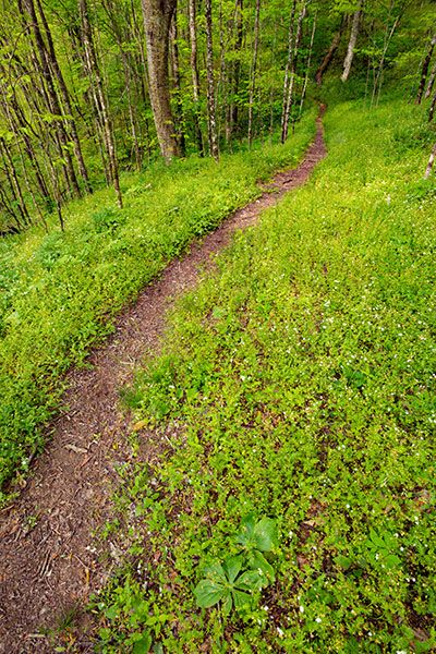
Wildflowers, scenic views, streams, and enchanting forests await you on Flat Creek Trail in Great Smoky Mountains National Park. It’s off the beaten path, and the crowds aren’t as suffocating as in the more popular areas of the park. A waterfall is here, too, and it’s a high one. You just can’t see it.
Flat Creek Falls is marked on maps and is listed in some park literature, so many people who hike Flat Creek Trail think they’ll see it. However, unless you embark on a difficult bushwhack, all you’ll see is the brink of the falls and the top of a ridiculous scramble path that doesn’t lead to a good view.
Years ago, the waterfall was promoted as a destination for park visitors and was even marked on trail signs, but because of safety concerns and resource protection, the park would prefer that the public keep away.
In early spring and after a good rain, you used to be able to see Flat Creek Falls fairly well from the road, 0.6 miles before the trailhead and 4.6 miles from the Blue Ridge Parkway. However, the last time I drove by in May 2026 I couldn’t see anything. It could be because the trees had leafed out early. In summer, you never could see anything.
(18-01-137284)
Driving Directions
Open driving directions in map appAt Wolf Laurel Gap, located at Milepost 458.2 on Blue Ridge Parkway, turn onto Heintooga Ridge Road. Drive 5.2 miles to Flat Creek Trailhead, on the left. The trailhead is the same for Bunches Creek Falls.
Heintooga Ridge Road is closed in winter.
Hiking Directions
Quick Glance
Hike Flat Creek Trail 0.7 miles to a nondescript side path on the left. The side path leads to the top of the falls.
Detailed Look
Hike Flat Creek Trail. In about 0.2 mile, the trail crosses Bunches Creek. Bunches Creek Falls is downstream. Continue the trail. In 0.7 miles from the trailhead, there is a faint side path on the left. On my last visit, there was a trail sign here indicating that it is 0.7 miles to Heintooga Ridge Road (back the way you came) and 1.9 miles to Heintooga Picnic Area.
The sign does not mention the falls and if it’s missing, the path will be easy to miss if you don’t pay close attention. (When you get to the falls and try to find a decent view, you’ll understand why the park does not put it on the trail sign.)
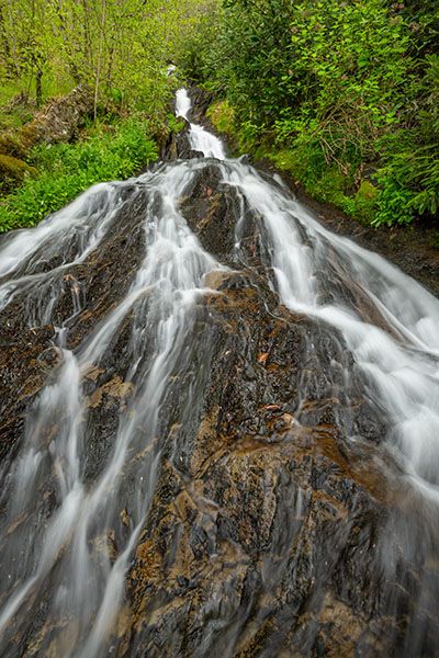
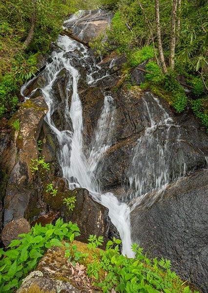
The path descends a little over 0.1 miles to the creek near the top of the falls. There is no good view of the falls and the rocks are very slippery. This is not a safe place to be!
A very steep and dangerous scramble path descends to a point near the base of the main upper section of the falls, but the view is not very good and it’s definitely not worth taking this path for it.
There is a decent view of the main upper section on the river-right side. To reach it, you can cross the creek above the falls and descend the river-right side. This is not recommended either, but it’s easier and safer than going down the river-left side. A big concern with the river-right route is that that side of the creek is lush with spring ephemeral wildflower growth. You need to be extremely careful to protect both yourself and the plants.
| Accessibility: | Hiking trail and bushwhack |
| County: | Swain |
| River Basin: | Little Tennessee |
| Watercourse: | Flat Creek |
| Watershed: | Small |
| Type and Height: | Steep, sliding cascade with a main drop of about 50 feet Height estimated. |
| Landowner: | Great Smoky Mountains NP |
| Beauty Rating: | 4 |
| Elevation: | 4740 feet |
| USGS Map: | Bunches Bald |
| Hike Difficulty: | Difficult |
| Hike Distance: | About 0.9 miles |
| Waterfall GPS: | 35.54937, -83.17218 |
| Trailhead GPS: | 35.55411, -83.1639 |
Photo Gallery
Click a photo to enlarge.