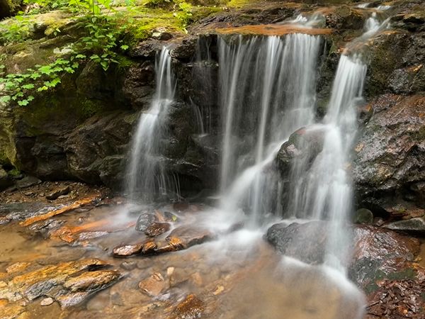
Forrest Falls
Shope Creek Falls
!
Forrest Falls is a nice snack break on a hike or bike ride in the Shope Creek trail system, but it falls short as a waterfalling destination. Really short. As in 6.5 feet short! That said, despite its height, it’s pretty.
The Shope Creek area has been part of Pisgah National Forest for some time, but it has only recently been easily accessible to the public. With its closeness to Asheville and multi-use trail system, it has become a popular destination among day hikers and mountain bikers.
None of the trails are signed, but most map apps show them, and there are several online resources available. Among the best is Jordan Mitchell’s HikeWNC.info and WNCOutdoors.info. Here’s a good introductory page for Shope Creek from those sites.
Jordan discusses three other waterfalls in the Shope Creek area: Casita Falls, High Swan Falls, and Wolfden Falls. I’ll get to them as soon as I can.
Forrest Falls. (077F1-256747)
Driving Directions
Open driving directions in map appFrom Asheville, turn on Riceville Road (SR 2002) from US 70, right beside the veteran’s hospital. Drive 3.65 miles and turn left on Bull Creek Road (SR 2418). Drive 0.1 miles and bear right on Shope Creek Road (SR 2426). Drive 2.15 miles and continue straight. You’ll immediately cross Shope Creek on a concrete ford and the road becomes unpaved and a little rough. You’ll reach the parking area, on the left, at 0.15 miles from the creek.
Hiking Directions
Quick Glance
Follow old road beyond gate to fork. Turn left and ascend a half mile to a side path on right ( GPS 35.663412, -82.438032). Take path, cross branch, and ascend to 4-way junction. Go left and ascend to T-junction. Turn right and reach falls in 100 yards.
Detailed Look
From the lower end of the parking area, a short path leads a feet to the dirt road. Turn left, away from civilization. Pass by the gate and and do not take the path forking right just beyond gate. In a little over 200 yards of gentle ascent, you’ll reach a fork. (Look at the cool pattern in the rocks imbedded in the ground here.)
Turn left at the fork and begin a moderate ascent. Stay on main road at all side paths. Reach another fork at 0.3 miles from the gate. Turn right, on the more obvious path. The old road ascends more steeply now and comes to a side path on the right at 0.2 miles from the fork. GPS coordinates for this point are 35.663412, -82.438032.
Take the side path and cross a small stream in 50 yards, then ascend 100 yards to a 4-way intersection. To the left and right is an old road. Straight ahead is a trail. Turn left and ascend to a T-junction at 0.15 miles. Turn right and in just over 100 yards you’ll come to a short side path on the right that leads down to the falls. Alternatively, you can continue the trail for 100 feet, cross Shope Creek, and take the path on the other side that leads down to the falls. That path is tad longer, but less steep.
For the return hike, you can continue the trail beyond Shope Creek and, if taking everything to the right, arrive back at the 4-way intersection. Also, there are tons of trails all over the place here that can be combined to make several loop hike options.
| Accessibility: | Hiking trail |
| County: | Buncombe |
| River Basin: | French Broad |
| Watercourse: | Shope Creek |
| Watershed: | Very small |
| Type and Height: | 6.5' freefall and cascade Height measured with rangefinder. |
| Landowner: | Pisgah NF, Grandfather RD |
| Beauty Rating: | 2 |
| Elevation: | 3240 feet |
| USGS Map: | Craggy Pinnacle |
| Hike Difficulty: | Easy/moderate Very short, steepish path to base. |
| Hike Distance: | About 1 mile |
| Waterfall GPS: | 35.667482, -82.436377 |
| Trailhead GPS: | 35.65452, -82.440493 |
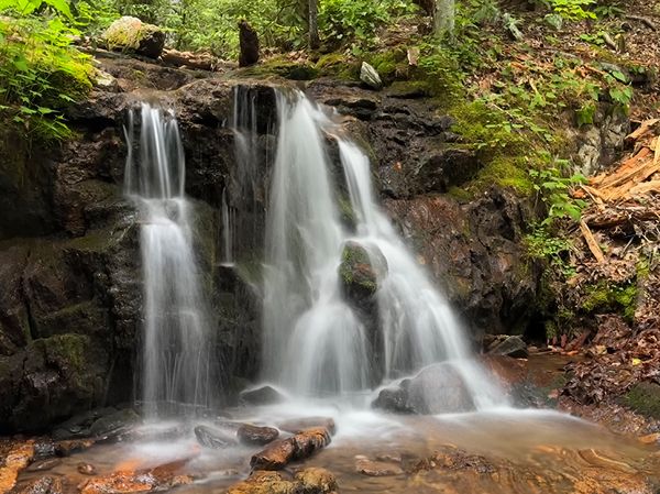
Photo Gallery
Click a photo to enlarge.