
Indian Camp Creek Falls
!
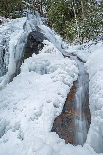
Here’s a waterfall I promise you’ll have all to yourself, and it’s a nice one, too. It flows over mossy rocks studded with herbaceous plants. Wildflowers carpet the surrounding slopes in spring.
(011B-116621)
Driving Directions
Open driving directions in map appFrom US 441 Business in downtown Franklin, drive 2.6 miles north on NC 28 (Harrison Avenue at the start) and turn left on Airport Road (SR 1434). Drive 2.3 miles to a T intersection. Turn left here onto Olive Hill Road (SR 1387) and drive 3.8 miles to another T. Turn left onto Upper Burningtown Road and follow it 2.4 miles to where the pavement ends at a small turnaround. Park here unless you have a four-wheel-drive vehicle.
Hiking Directions
Quick Glance
Hike or drive a four-wheel-drive vehicle 0.25 miles to the end of the road. Turn right and cross Burningtown Creek, then work your way to the right to pick up an old logging grade. Follow the grade to a crossing of Indian Camp Creek. Follow the creekbed upstream for about 50 yards to pick up the old logging road on river left. You’ll soon come to another crossing. Beyond the crossing, the trail climbs steeply about 0.5 miles to the falls.
Detailed Look
Note that I haven’t hiked to this waterfall since February 2015. At that time, the trail was overgrown and had many downed trees over it. If no maintenance has been performed (I doubt any has) it could be in pretty bad shape now.
Hike or drive a four-wheel-drive vehicle 0.25 miles to where the road ends at a small turnaround. From there, go right and cross Burningtown Creek. (Don’t take the gated road straight ahead.) After crossing, work your way to the right through the rhododendron for a short distance to pick up an old logging grade. Follow the grade to a crossing of Indian Camp Creek. This point is about 0.18 miles from the Burningtown Creek crossing. Follow the creekbed upstream for about 50 yards to pick up the old logging road on river left. The road is overgrown and has many downed trees covering it. Just head upstream. You’ll soon come to another crossing. Beyond the crossing, the trail climbs exceedingly steeply for a few yards, then becomes a little saner. From the crossing, it’s about 0.5 miles to the falls. You can see it easily from the trail, but for the best view and for photos, scramble down the bank to the base.
| Accessibility: | Hiking trail |
| County: | Macon |
| River Basin: | Little Tennessee |
| Watercourse: | Indian Camp Creek |
| Watershed: | Very small |
| Type and Height: | Steep, cascading falls about 60 feet high Height estimated. |
| Landowner: | Nantahala NF, Nantahala RD |
| Beauty Rating: | 6 |
| Elevation: | 3080 feet |
| USGS Map: | Wayah Bald |
| Hike Difficulty: | Difficult |
| Hike Distance: | Approx. 1.15 miles |
| Waterfall GPS: | 35.22361, -83.53761 |
| Trailhead GPS: | 35.21467, -83.53123 |