
Kuykendall Falls
!
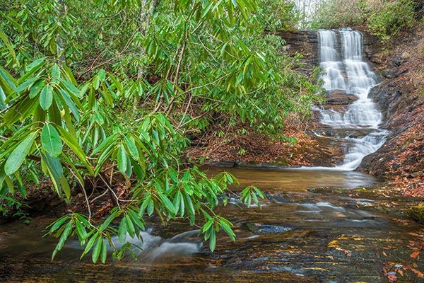
Thanks to a hike that measures nearly 5 miles one way and the extremely steep climb down the mountainside, this waterfall is not for everyone. But it’s a rewarding hike for those who go. The falls is very scenic and photogenic, and if you make the hike in winter, you’ll also be rewarded with numerous distant views from the forest road.
The Rosman topo map has Kuykendall Falls in the wrong location. It’s a little way downstream from the mark.
(018D-113518)
Driving Directions
Open driving directions in map appIf you’re in the Davidson River vicinity of the national forest, drive to Gloucester Gap, which is on FS 475 some 6.05 miles from US 276. From the gap, turn left on FS 471 (Catheys Creek Road) and drive 4.45 miles to the gated FS 5361, on the left. This point is 0.35 miles before Catheys Creek Falls and you’ll pass Upper Shoals on the way.
To get here from downtown Brevard, drive 3.3 miles west on US 64 and turn right at the sign for Kuykendall Group Camp. After turning, make an immediate left on Catheys Creek Road and drive 3.55 miles to FS 5361, on the right. You’ll pass Catheys Creek Falls on the way. Catheys Creek Road is unpaved after 0.7 miles.
Hiking Directions
Quick Glance
Walk 4.5 miles on FS 471 and bushwhack down the bank toward the sound of falling water.
Detailed Look
Note that these directions are based on the trek I made in 2014. Some aspects of the hike may have changed.
Take FS 5361 beyond the gate. The first 4.5 miles of the hike follow this old logging road on a moderate, winding, undulating course. The biggest problem is figuring out exactly where to leave the road and climb down the bank to the falls. There are no good indicators, and it’s impossible to guess when you’ve hiked 4.5 miles. I’ll mention a few landmarks along the way and try to give you enough information to pick the right spot to leave the road.
After 0.95 miles, you’ll cross Kagle Branch and start skirting the southwest flank of Kagle Mountain. At 1.98 miles, you’ll swing left around a ridge where a flat, open area is on the outside of the curve. In another 0.9 mile, make a left swing around a ridge with a flat, open area to the right. You’ll do the same thing for a third time in another 0.88 miles. At this point, you're about 3.76 miles from the trailhead. To the northwest are views of the imposing cliffs of Cedar Rock Mountain.
At 0.63 miles from the open area, you’ll cross a small stream that may not have much flow in summer. In another 110 yards, you’ll swing around a dry drainage. In just under 0.1 miles from the drainage, make a sharp left swing around a ridge. The GPS reading for this point is 35.24288, -82.78928.
Continue on the road for about 135 feet, then turn right and follow the drainage down to Kuykendall Creek. There is no trail, but you should come out close to the falls if you head toward the sound of falling water. It’s less than 0.2 miles down to the falls. It’s steep, and once you reach the creek you’ll have to wade through dog hobble and rhododendron.
On my last visit, there was flagging tape marking a route down the ridge. But that route doesn’t lead to the falls. You can follow the ridge down to the creek, but you’ll come out below the falls and have to do a lot more bushwhacking.
Other Options
Study a hiking map and you’ll see several options for accessing the falls from the Davidson River area to the north or from a trailhead farther up Catheys Creek Road. There are nice hiking trails all over the place in this area.
| Accessibility: | Forest road and bushwhack |
| County: | Transylvania |
| River Basin: | French Broad |
| Watercourse: | Kuykendall Creek |
| Watershed: | Small |
| Type and Height: | Short free fall with cascades over mini-ledges below; total height is about 35 feet Height estimated. |
| Landowner: | Pisgah NF, Pisgah RD |
| Beauty Rating: | 6 |
| Elevation: | 3040 feet |
| USGS Map: | Rosman |
| Hike Difficulty: | Moderate road walk and Class II bushwhack |
| Hike Distance: | About 4.7 miles |
| Waterfall GPS: | 35.24456, -82.78782 |
| Trailhead GPS: | 35.22787, -82.80792 |