
Lake Sequoyah Dam
!
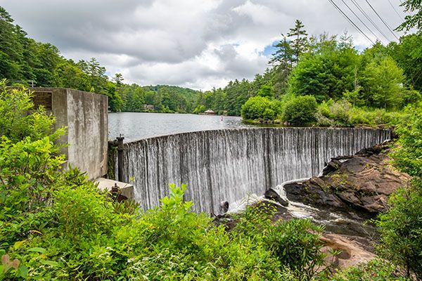
Easily viewed from the road, Lake Sequoyah Dam is a popular photo subject for travelers through Cullasaja River Gorge. The dam marks the beginning of the gorge, sitting at the top of Kalakalaski Falls #1. The town of Highlands constructed the dam in 1926 to provide water and hydroelectric power.
A common misconception about the lake is that it flooded Kalakaleskies Falls, or at least the upper tier of it. But dams are built on top of waterfalls, not below. Anyone doubting this needed only to drive by in 2015 when the town drained the lake for water intake and dam repairs. The draining revealed more than just a flat lakebed above the dam. It also exposed a wooden boat that sank in 1930.158 The boat is on display at Highlands Historical Society Museum.
Read the Cullasaja River section for an overview of the river and its waterfalls, including a list of landmarks with mile markers. You can find it by clicking the Little Tennessee River Basin button on the Rivers page.
(025R-256828)
Driving Directions
Open driving directions in map appFrom the junction of US 64 and NC 106 in Highlands, drive 1.9 miles west on US 64 and park in the pullout on the left, just past the lake.
Hiking Directions
Quick Glance
Get out of the car.
Detailed Look
You can view the dam from the pullout. A short path descends to the base of the dam at the top of Kalakalaski Falls #1.
| Accessibility: | Roadside view |
| County: | Macon |
| River Basin: | Little Tennessee |
| Watercourse: | Cullasaja River |
| Watershed: | Medium |
| Type and Height: | Small concrete dam about 22 feet high Height measured with rangefinder. |
| Landowner: | Town of Highlands |
| Experience Rating: | Good |
| Elevation: | 3600 feet |
| USGS Map: | Highlands NC/GA |
| Hike Difficulty: | View roadside |
| Hike Distance: | Roadside view and short walk |
| Waterfall GPS: | 35.067582, -83.224882 |
| Parking GPS: | 35.067879, -83.225315 |