
Little Moore Cove Falls
!
Little Moore Cove Falls is in the cove to the west of Moore Cove Falls. It’s nearly identical except it’s only half the size. Although smaller, Little Moore Cove Falls is just as scenic.
Unfortunately, in all the times I’ve visited it over the past 35 years, the base has been a cluttered mess of fallen logs and branches. I haven’t been back since Tropical Storm Helene, so I don’t imagine it has gotten any better.
I still recommend this waterfall, though. You’ll leave the crowds behind at Moore Cove Falls and enjoy a peaceful visit.
Four other waterfalls are nearby: Upper Little Moore Cove Falls, Moore Creek F1, Upper Moore Cove Falls, and of course Moore Cove Falls that you pass by on the way to Little Moore Cove Falls.
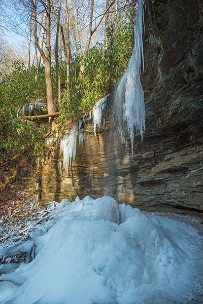
Little Moore Cove Falls after several days of freezing weather. (065J-115408)
Driving Directions
Open driving directions in map appFrom the US 64/US 276/NC 280 junction near Brevard, drive 6.7 miles north on US 276 to the parking area on the right, just before the Looking Glass Creek bridge. From the Blue Ridge Parkway, the trailhead is 8.4 miles south, on the left.
Hiking Directions
Hiking Directions for Moore Cove Falls, Upper Moore Cove Falls, Little Moore Cove Falls, Upper Moore Cove Falls, and Moore Creek F1
Follow the obvious trail to Moore Cove Falls.
To see Upper Moore Cove Falls, walk behind Moore Cove Falls and climb the river-right bank on the well-worn scramble path.
To see Little Moore Cove Falls, take the obvious path on the left, about 100 feet before the Moore Cove Falls viewing area. After 40 feet, cross the creek into a small clearing, then leave the clearing to the left and cross the creek that flows from Little Moore Cove Falls. From there, ascend 200 feet to an open view of the falls. A path goes down to the creek from this point and follows it upstream on river right to an open view near the base of the falls. To reach the base, cross the creek and continue up the river-left side.
To see Upper Little Moore Cove Falls, don’t descend to the creek at the first viewpoint of Little Moore Cove Falls. Instead, continue up the fairly steep trail for just over 0.1 miles to a small creek crossing. In winter, you may glimpse the upper falls along the way.
At the crossing, the trail curves right toward the falls. Less than 100 yards from the crossing, the trail swings left and begins following the creek upstream. This is where you leave the trail. Look for small dip in the outside berm on the trail. The GPS coordinates for the spot are: 35.312497, -82.778996.
Once you leave the trail, descend toward the sound of falling water. You’ll likely come to a small cliff. Work your way around so you can follow the base of the cliff to the falls. It’s not very far from the trail down to the falls, but it’s a Class III bushwhack.
To see Moore Creek F1, probably the easiest option is to hike the trail to the point where you drop off to go to Upper Little Moore Cove Falls, but continue on the trail for another couple hundred feet to where the slope down to the creek becomes less steep. Leave the trail there, go down to the creek, and follow it downstream. You’ll soon come to the falls.
| Accessibility: | Hiking trail |
| County: | Transylvania |
| River Basin: | French Broad |
| Watercourse: | Moore Creek? See “Naming” for a discussion about the creek name. |
| Watershed: | Very small |
| Type and Height: | Freefalling falls over a bluff, with a total height of about 35 feet Height measured with rangefinder. |
| Landowner: | Pisgah NF, Pisgah RD |
| Beauty Rating: | 5 |
| Elevation: | 2680 feet |
| USGS Map: | Shining Rock |
| Hike Difficulty: | Easy/moderate |
| Hike Distance: | About 0.8 miles |
| Waterfall GPS: | 35.31197, -82.77863 |
| Trailhead GPS: | 35.30508, -82.77439 |
Photo Gallery
Click a photo to enlarge.