
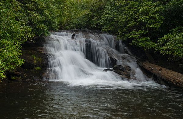
Lower Stick Falls
!
Although small and unremarkable, Lower Stick Falls has features that make it enjoyable to visit. It has a nice pool, with Little Creek emptying directly into it. The pool and waterfall are draped in rhododendron and mountain laurel, giving the setting a tropical look.
(003G-213074)
Driving Directions
Open driving directions in map appFrom Horse Cove Road, drive 1.7 miles on the unpaved Walkingstick Road (SR1608) and park in the small pullout on the right side.
Trailhead for Stick Falls, Upper Stick Falls, Lower Stick Falls, and the lower trailhead for Slick Stick Falls.
Hiking Directions
Quick Glance
Plug the GPS coordinates in your phone and head straight to the falls.
Detailed Look
Four waterfalls—Upper Stick Falls, Stick Falls, Lower Stick Falls, Slick Stick Falls— are accessed from the trailhead, all of them fairly close together and all of them gnarly and potentially confusing to reach. I’ll give info for all four, as it’s hard to isolate them.
The usual suggestion to follow the sound of falling water works here, but you’ll likely not know which waterfall you come to first and won’t know whether to go upstream or down for the others.
To view Upper Stick Falls, you’ll need to go straight to it. To view Stick Falls, you can go straight to it or swing around from Upper Stick and then descend to it. To view Lower Stick Falls, you can go straight to it, or swing around from Stick and descend to it. You cannot creekwalk the entire distance between all three falls, though you can creekwalk part of the way between Stick and Lower Stick.
Probably the easiest way to see all three falls on the same hike is to start with Upper Stick, then do Stick, and then Lower Stick. Upper Stick isn’t very remarkable and you won’t miss out on much if you skip it. But don’t miss Stick!
So, for all three, walk upstream (toward Horse Cove) along the road for a couple hundred feet to a point about halfway between two utility poles. Strike out through the woods at an angle of 300 degrees and try to stay on that heading. If you stray to the left, you’ll come out on the cliffs by the creek. Too far to the right is no big deal as you can just creekwalk downstream.
You want to come to the creek above the falls and then follow the creek downstream. It’s relatively easy to walk down the falls to the base.
To reach Stick Falls, which is only a few yards downstream, you’ll need to go back up the bank and swing around and find a break in the cliff that you can descend to the base of the falls. It’s not fun!
To reach Lower Stick Falls, climb back up from Stick Falls and swing around to avoid the cliff area before descending.
When you get back to your car, reach around and pat yourself on the back for a job well done in seeing these waterfalls that are so close to the road but so difficult to get to.
If you want to add Slick Stick Falls to the hike, cross the creek on the downstream end of the pool below Lower Stick Falls and follow Little Creek upstream. You’ll need to get into the woods briefly once or twice but stay with the creek as much as possible. I’ve done this hike several times, each time trying a different route, and the creek is definitely the easiest and fastest way for me.
You can also reach Slick Stick Falls from an upper trailhead. I don’t recommend that route, but you can find details for it on the Slick Stick Falls page.
| Accessibility: | Bushwhack |
| County: | Macon |
| River Basin: | Savannah |
| Watercourse: | Big Creek |
| Watershed: | Small |
| Type and Height: | Steep cascading falls, 12’ high Height measured with rangefinder. |
| Landowner: | Nantahala NF, Nantahala RD |
| Beauty Rating: | 5 |
| Elevation: | 2600 feet |
| USGS Map: | Highlands NC/GA |
| Hike Difficulty: | Difficult |
| Hike Distance: | Approx. 0.1 miles |
| Waterfall GPS: | 35.018928, -83.163981 |
| Trailhead GPS: | 35.020342, -83.162999 |