No Name Cove Falls
!
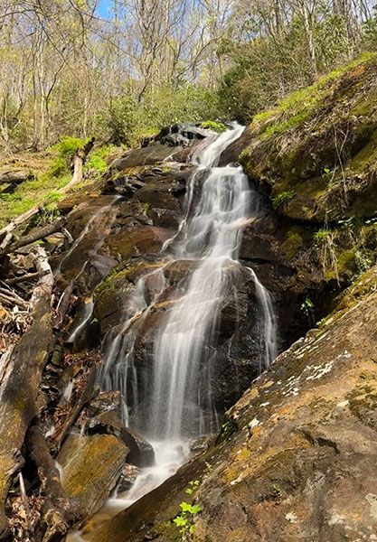
No Name Cove Falls, like most of the others nearby, is unremarkable, but it’s not too difficult to reach. It’s one of four significant waterfalls, plus several smaller falls, that you can see in a half-day outing from the same trailhead.
The main upper section of the falls. (065Z3-262700
Driving Directions
Open driving directions in map appFrom the junction of US 64, US 276, and NC 80 in Brevard, drive north on US 276 for 10.3 miles (passing Looking Glass Falls on the way) and turn left on the unpaved FS 475B (Headwaters Road). From Blue Ridge Parkway, it is 4.7 miles south on US 276 to this point. Drive 0.15 mile on FS 475B and park on the left, just before the bridge.
Hiking Directions
There are two routes to No Name Cove Falls. You would choose the longer route if you’re including Cherry Cove Falls and/or Bennett Cove Falls on the hike. I’ll describe both in the Detailed look section. The Quick Glance is for the shortest route.
Quick Glance
Start on FS 5032, which is across the road from the parking area. In 80 yards you’ll come to a gate. Right before the gate is a side path on the right. Take this path and ascend to rejoin FS 5032. Cross over the road and walk up through the wildlife clearing, then take the path through the woods to the falls.
Detailed Look
Start on FS 5032, which is across the road from the parking area. In 80 yards you’ll come to a gate. Right before the gate is a side path on the right. Take this path and ascend a little over 0.25 miles to rejoin FS 5032 farther up the mountain.
There is a wildlife clearing at this point. Cross over the road and walk 400 feet to the upper end of the clearing. A faint path enters the woods from the middle of the clearing. It is easily followed if you pay close attention. The path ascends 0.15 miles to a point a short distance downstream from the falls. Reaching the base of the main upper section requires a difficult scramble.
If you hike to Cherry Cove Falls/Bennett Cove Falls first, when you get back to FS 5032, turn left on the road and swing around the sharp switchback. It is 0.6 miles on FS 5032 to the wildlife clearing you need to walk through. You’ll pass one other clearing shortly before this one, and cross two obvious streams, the second one right before the clearing.
| Accessibility: | Hiking trail |
| County: | Transylvania |
| River Basin: | French Broad |
| Watercourse: | Tributary of Looking Glass Creek |
| Watershed: | Very small |
| Type and Height: | High cascading and freefalling falls; overall height is over 100 feet I couldn’t get an accurate height measurement with the rangefinder. Suffice it to say that if you include all the drops, this waterfall is very high. |
| Landowner: | Pisgah NF, Pisgah RD |
| Beauty Rating: | 4 |
| Elevation: | 3560 feet |
| USGS Map: | Shining Rock |
| Hike Difficulty: | Moderate Class I bushwhack See Hiking Directions for the longer route if you’re including Cherry Cove Falls or Bennett Cove Falls on the hike. |
| Hike Distance: | 0.5 miles |
| Waterfall GPS: | 35.34527, -82.7958 |
| Trailhead GPS: | 35.3391, -84.792 |
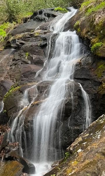
Photo Gallery
Click a photo to enlarge.