
Red Rock Falls
!
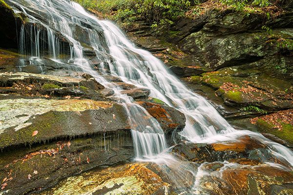
The most interesting aspect of this waterfall is the rock it falls over. It’s full of swirling streaks of quartz and has colorful red and orange hues. Photographers can isolate sections of the falls that show the water and colorful rock.
A short distance upstream from Red Rock Falls is a scenic little waterfall dropping off a ledge. The topo map shows trail #128 continuing beyond the falls and reaching the Blue Ridge Parkway at Devils Courthouse. It does, sort of. You’ll find remnants of a trail, but it’s overgrown, and the hiking is rough in places.
A cascading falls is located around the 4,700-foot elevation, but it’s probably not worth the hike. Using two vehicles, this would make an okay shuttle hike, but you might want to hike in the downstream direction, since the trail is steep toward the top.
(022H-115267)
Driving Directions
Open driving directions in map appThe trailhead is the same as Chestnut Falls and the lower waterfalls on Chestnut Creek, Cody Falls, Courthouse Falls, and Upper Courthouse Falls. From Beech Gap on Blue Ridge Parkway, drive 6.65 miles south on NC 215 and turn left on the gravel FS 140 (Courthouse Creek Road). FS 140 is 10.4 miles north of US 64. Follow the road for 2.5 miles to the gate and park in the cleared area on the left. This trailhead is 0.2 miles farther on FS 140 than the trailhead for Kiesee Falls and Upper Kiesee Falls.
Note that as of this writing, FS 140 is closed indefinitely. If it is closed when you visit, you’ll have to park in the area beside NC 215, across from FS 140, and walk the road.
Hiking Directions
Quick Glance
From the gate, follow FS 140 to the end at Upper Courthouse Falls, then follow the path that leads upstream to Red Rock Falls. (But you had better read Detailed Look before doing this!)
Detailed Look
I haven’t hiked to Red Rock Falls since 2014 and the information I’m providing is based on that time. Given how the access route follows closely along the creek, things could have changed, especially from Tropical Depressions Fred in 2021 and Helene in 2024.
Hike FS 140 beyond the gate. After 0.1 miles you’ll come to FS 5031 on the right. You would take that road for Chestnut Falls. Continue straight on FS 140 and descend to the bridge over Courthouse Creek, 0.5 miles from the gate. The trail on the left leads to Courthouse Falls. Continue on FS 140 for 0.2 miles to a sharp left switchback. FS 140B swings to the left. You want to continue straight ahead on FS 140 and follow the creek upstream.
After hiking 0.75 miles from the switchback you’ll come to the creek near Upper Courthouse Falls, easily seen a short distance upstream. At this point, you must leave the old road and take the trail that turns left and heads upstream, steeply ascending. In a few yards, you’ll come to a side path on the right that leads to the top of the lower portion of Upper Courthouse Falls. A few feet upstream, the upper portion drops 7 feet into a scenic pool. Below the pool, the creek cascades over water-sculpted rock before going over the lower slide. It’s a photogenic spot but be careful walking out on the rock. It’s quite slippery when wet or covered in leaves.
Back on the main trail, continue the steep but short climb and follow the creek upstream. For the remainder of the hike, the trail is narrow, ungraded, rocky, and rooty. It also clings to a steep bank in places. The hiking experience is not terribly pleasant.
About 0.3 mile from FS 140, you’ll pass a scenic 10-foot waterfall dropping into a small pool. Just above this falls is a small slide. You’ll have to cross the creek above the slide. This crossing and the next three are rockhoppable in normal flows but could be tricky if the water’s up. Less than 0.1 miles farther, you’ll cross the creek again. Less than 0.1 miles from this crossing, you’ll cross the creek a third time, just below where two forks cascade into a small pool.
The trail follows the river-left side of the right fork. At the start, it’s overgrown and it appears that the better route climbs the bank. Stay close to the creek and the trail will soon open up. At 0.14 miles from the crossing, cross again for the fourth and final time. A few feet beyond this crossing, the path dips to the creek. You’ll have to walk in the creek bed a short distance. About 0.1 miles from the last crossing you’ll come to the falls. You can see it easily from the trail. But for the best view, scramble down the bank to the base.
| Accessibility: | Hiking trail |
| County: | Transylvania |
| River Basin: | French Broad |
| Watercourse: | Courthouse Creek |
| Watershed: | Small |
| Type and Height: | Multi-ledge cascade about 30 feet high Height estimated. |
| Landowner: | Pisgah NF, Pisgah RD |
| Beauty Rating: | 5 |
| Elevation: | 4160 feet |
| USGS Map: | Sam Knob |
| Hike Difficulty: | Moderate/difficult |
| Hike Distance: | About 2.1 miles |
| Waterfall GPS: | 35.29186, -82.90383 |
| Trailhead GPS: | 35.269447, -82.8891 |