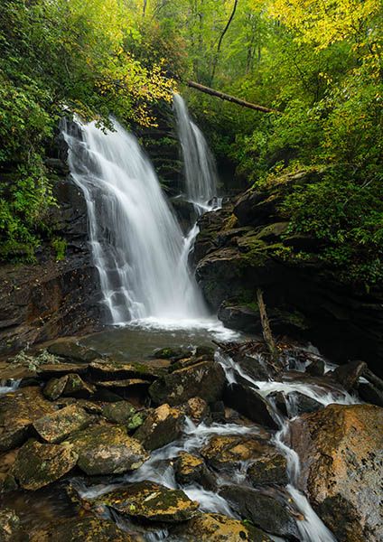
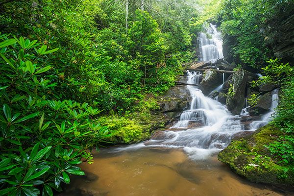
Reese Place Falls
!
Reese Place Falls is among the more scenic waterfalls in Transylvania County, which is saying something considering that the county features some of the more spectacular waterfalls in the state.
Headwaters State Forest, in which Reese Place Falls is located, is one of the state’s newer public lands, opening in 2018. For several years, there was no public trail access to Reese Place Falls, but there is now a nice new trailhead for the waterfall.
(044A-109366)
Driving Directions
Open driving directions in map appFrom the Rosman area, turn off US 64 onto US 178. Drive south 1.6 miles (passing through Rosman) and turn left on East Fork Road (SR 1107). Drive 3.7 miles and turn right to remain on East Fork Road. Drive 4.7 miles to the trailhead, on the right, which is on the outside of a sharp left curve.
From the Connestee Falls area, turn off US 276 onto East Fork Road and drive 3.6 miles to the trail on the left, which is on the outside of a sharp right curve.
Hiking Directions
Quick Glance
Follow the (hopefully) obvious trail to the falls. You must do a little scrambling and cross a small branch of the creek to get to the best viewing point.
Detailed Look
I haven’t hiked to the waterfall since 2020. At that time, the trail was in the process of being constructed and I couldn’t make detailed notes. Be prepared to find different conditions from the information I’m providing here. Hopefully, the trail is now blazed and signed and easy to follow.
Enter the woods at the far end of the parking area. Descend about a quarter mile and cross a small creek, then ascend less than 100 yards to an old road. Turn left, walk a short distance, then then turn right. Now descend about 0.2 miles to another old road and turn left. Follow this road for a half mile, all the way to the end. From here a small path runs about 100 feet to a fork. The right fork leads to the base of the lower small falls. The left fork runs about 200 feet up to the viewing point for the main upper sections of the falls. You must cross a portion of the creek to reach an open view. This could be a little dicey for some.
| Accessibility: | Hiking trail |
| County: | Transylvania |
| River Basin: | French Broad |
| Watercourse: | East Fork French Broad River |
| Watershed: | Small |
| Type and Height: | 60-foot-high waterfall, falling in two sections Height estimated from LiDAR map. This is for the main upper two sections and does not include the small lower falls. |
| Landowner: | Headwaters State Forest |
| Beauty Rating: | 8 |
| Elevation: | 2680 feet |
| USGS Map: | Table Rock SC/NC |
| Hike Difficulty: | Moderate, with a potentially tricky creek crossing |
| Hike Distance: | Approx. 1.1 miles |
| Waterfall GPS: | 35.11559, -82.7089 |
| Trailhead GPS: | 35.115811, -82.722274 |
Photo Gallery
Click a photo to enlarge.