Secret Falls
Big Shoals
!
Secret Falls hasn’t been a secret for a couple decades. What was once a clandestine getaway for those in the know is now regularly visited by the rest of us. It’s not crowded, mind you. It’s just not the well-guarded secret it once was.
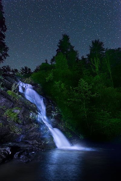
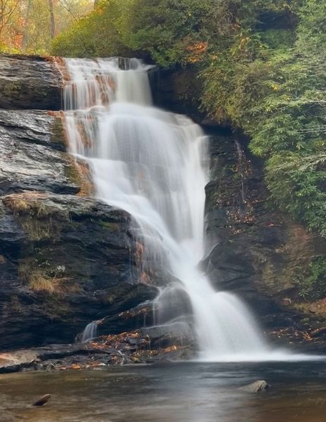
The waterfall is among the more scenic waterfalls in the region. It has a nice pool and a sandy beach that are perfect for wading and lounging. A short distance downstream is a smaller, river-wide falls that’s also picturesque. You’ll have to do some scrambling for a good view of it. Be careful, as the rocks are slippery.
The Forest Service has recently constructed new steps leading to the base of the falls and removed the big tree you had to crawl over. The new steps make the hike much easier and less damaging to the fragile slope beside the falls.
When I published the first edition of my North Carolina Waterfalls book in 1994, you could not access Secret Falls without bushwhacking or trespassing. Sometime before the second edition of the book in 2005, the Forest Service built a new trailhead for the falls on national forest property. Then sometime in the 2010s, I think, the Forest Service acquired that tract of private property that the old trail passed through. Don’t go looking for it, though. There is very limited parking, the route is heavily overgrown, and there is no good reason not to use the sanctioned trail.
(257723)
Driving Directions
Open driving directions in map appYou can access the trailhead from Horse Cove, east of Highlands, or from NC 28, southwest of Highlands.
From Horse Cove Road, some 3.75 miles from US 64 in Highlands, turn right on the unpaved Walking Stick Road (SR1608). Drive 3.0 miles to FS 4567, on the right. (There is a creek ford on this road at 2.5 miles.) Drive 0.2 miles on FS 4567 to the trailhead, on the left. In winter, this road is gated, so you’ll need to park at the junction and walk up the road to the trailhead.
From NC 28, 4.1 miles south of US 64 in Highlands, turn left on Rich Gap Road (SR 1710). Drive 0.6 miles and turn right on FS 4567. Drive 2.0 miles to the trailhead on the right. FS 4567 is unpaved and a little rough. It is closed in winter, typically from December 15 to March 15, but foot travel is allowed.
Hiking Directions
With your back to the road, the trail begins at the far right corner of the parking area. It starts as an old forest road and is level for 0.25 mile, then descends moderately to cross a small stream at 0.4 mile. The trail then ascends and descends to another creek crossing, this one aided by a footlog. From the creek, ascend 0.1 mile to a junction where a faint trail continues straight but the more obvious path turns left. Go left and descend less than 0.1 mile to the top of the long series of steps that take you to the base of the falls.
| Accessibility: | Hiking trail |
| County: | Macon |
| River Basin: | Savannah |
| Watercourse: | Big Creek |
| Watershed: | Small/medium |
| Type and Height: | Very steep falls measuring 53 feet high Height measured using rangefinder. |
| Landowner: | Nantahala NF, Nantahala RD |
| Beauty Rating: | 8 |
| Elevation: | 2400 feet |
| USGS Map: | Highlands NC/GA |
| Hike Difficulty: | Moderate Class I bushwhack There is a longish set of steps leading down to the base of the falls. |
| Hike Distance: | 0.7 miles |
| Waterfall GPS: | 35.004609, -83.17141 |
| Trailhead GPS: | 35.008647, -85.166545 |
Photo Gallery
Click a photo to enlarge.