Sols Creek Falls
!
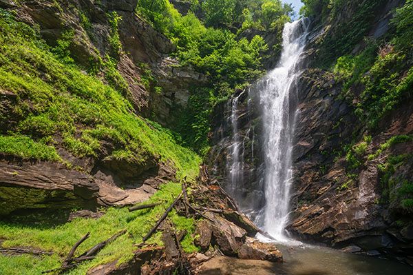
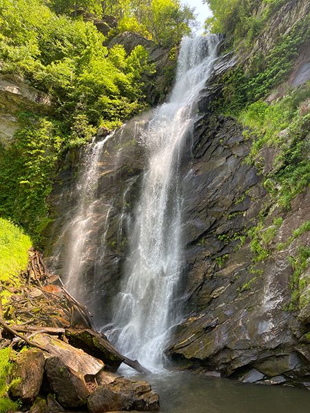
Sols Creek Falls is one of my favorite waterfalls in North Carolina—easily in my top 10, and maybe my top 5. More than almost any other waterfall in the state, it evokes the large, powerful waterfalls out West. The creek drops 150 feet over a massive cliff, landing with a thunderous roar.
Even at normal flow, the spray is powerful. If the water is just a little high, you’ll be soaked before you can get close enough for a good view.
The catch is that Sols Creek Falls is on private property. I’ve never seen a posted sign, and people visit it regularly, but going there means trespassing.
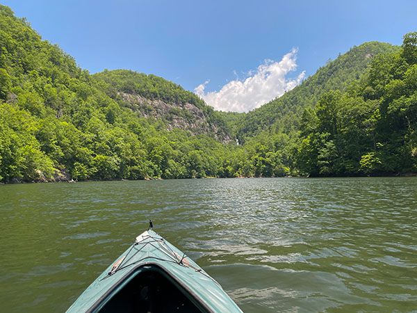
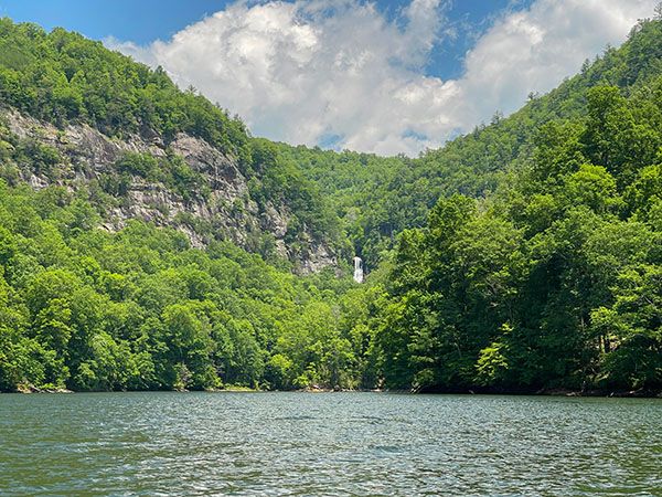
You can, however, see part of the waterfall without trespassing. Its upper section is visible from Bear Creek Lake, and it’s an impressive sight. You’ll need a boat, but that’s the most practical way to see it even if you hike to the base. The falls sit in a canyon ringed by massive cliffs, and reaching the base requires following the creek upstream.
The lake view alone is worth the trip. Bear Creek Lake is one of North Carolina’s more scenic mountain lakes, and the waterfall makes the outing especially memorable.
(035C-213855)
Driving Directions
Open driving directions in map appThe public boat landing for Bear Creek Lake is off NC 281. From NC 107, go south on NC 281 for 4.1 miles and turn right onto Bear Lake Road (SR 1137). From US 64, go north on NC 281 for 21 miles and turn left onto Bear Lake Road. Follow Bear Lake Road downhill for 0.6 miles to the boat landing.
Hiking Directions
Quick Glance
This one’s quick only if you have a motor on your boat!
Detailed Look
Follow the main lake channel upstream. After about 2 miles, you’ll reach a small island. Robinson Creek enters from the right, while the main channel swings left. Stay with the main channel, and Sols Creek Falls will soon appear straight ahead.
If you’re hiking to the falls (remember, this is private property) continue into the Sols Creek Cove. You’ll come to a small beach on the right. An obvious trail begins here and leads to the falls.
| Accessibility: | Boat trip and hiking trail |
| County: | Jackson |
| River Basin: | Little Tennessee |
| Watercourse: | Sols Creek |
| Watershed: | Small/medium |
| Type and Height: | 150 feet of sheer awesomeness Height measured with rangefinder. |
| Landowner: | Private |
| Beauty Rating: | 10 |
| Elevation: | 2880 feet |
| USGS Map: | Big Ridge |
| Hike Difficulty: | Moderate |
| Hike Distance: | About 2.5 miles on the lake and a quarter-mile hike |
| Waterfall GPS: | 35.237448, -83.035304 |
| Parking GPS: | 35.24401, -83.06409 |
Photo Gallery
Click a photo to enlarge.