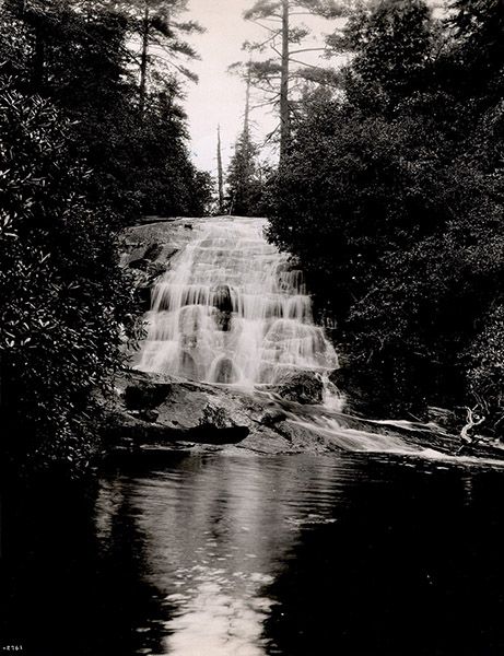
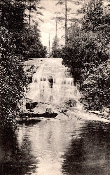
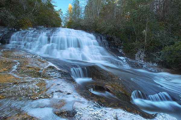
Upper Silver Run Falls
!
Most people who visit Silver Run Falls are unaware there is another waterfall is upstream. For those who can handle the initial climb up the rock and don’t mind ducking under rhododendron, the upper waterfall makes for a nice visit that you’ll likely have all to yourself. As far as I can determine, it’s on national-forest property but barely inside the line. The property upstream from the falls is part of Silver Run Preserve, owned by The Nature Conservancy.
There is an old, stacked stone pier of some sort at the base of the falls on the river-right bank. I have no idea what it was used for.
Driving Directions
Open driving directions in map appFrom US 64 in Cashiers, drive 4.05 miles south on NC 107 and park in the paved pullout on the left.
Hiking Directions
Quick Glance
Follow the trail to Silver Run Falls. Where the trail turns to drop down to the base of the falls, climb up the steep rock face, then weave through the rhododendron up to the Upper Falls.
Detailed Look
Follow the trail to Silver Run Falls. The trail first comes out at a point downstream from the falls, then continues up to reach the pool right at the base. Before the trail drops down to the base, it passes by a rock face that has roots on it. This is the route to the upper falls—a near-vertical climb, but mercifully short. It’s like climbing a ladder with roots as rungs.
You can skirt the base of the cliff for a short distance before climbing, but it won’t be much easier. And it’s more dangerous that way, as you then must traverse a steep slope at the top. In winter, the slope is covered in ice. The only other way is a wide bushwhack around the cliff, which will be just as tough as climbing the cliff, though maybe not as scary.
Once at the top of the cliff, work your way upstream along the paths, ducking under or climbing over the rhododendron on the way. There is no single trail, but rather several braids all over the place. Just keep heading upstream and you’ll get there. It’s about 0.1 miles from the top of the cliff.
| Accessibility: | Hiking trail |
| County: | Jackson |
| River Basin: | Savannah |
| Watercourse: | Silver Run Creek |
| Watershed: | Small |
| Type and Height: | Steep cascading falls about 20 feet high Height estimated. |
| Landowner: | Nantahala NF, Nantahala RD |
| Beauty Rating: | 6 |
| Elevation: | 3400 feet |
| USGS Map: | Cashiers NC/SC/GA |
| Hike Difficulty: | Difficult Requires a short but very steep climb up a rock face, using roots for support. |
| Hike Distance: | Approx. a quarter mile |
| Waterfall GPS: | 35.067055, -83.064304 |
| Trailhead GPS: | 35.06689, -83.06695 |
Historical Gallery
Click a photo to enlarge.