
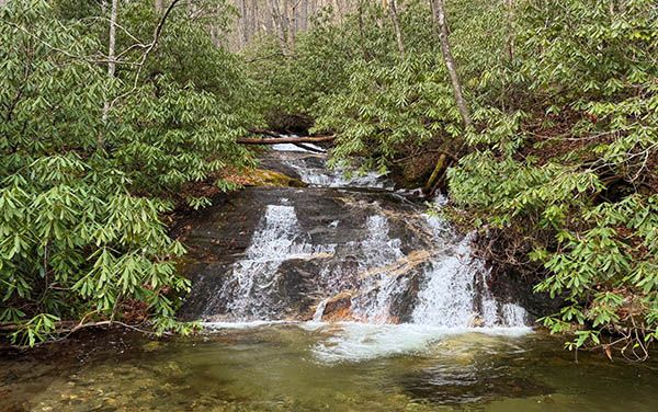
West Fork Falls
!
If you’re already in the area, perhaps visiting Picklesimer Rock House Falls or Chasm Falls, this is an okay one to add to the list, but I wouldn’t make a special trip for it.
(059Z18-258181)
Driving Directions
Open driving directions in map appFrom US 64 in Highlands, drive 5.9 miles south on NC 28 and turn right on Blue Valley Road (SR 1618). Blue Valley Road changes to gravel at 0.5 mile and becomes FS 79 when it enters Nantahala NF. Drive to the gate at the end of the road, 6.7 miles from NC 28. (At 3.7 miles from NC 28, you’ll come to a T-junction. FS 79C goes right; you want to go left to remain on FS 79.)
Hiking Directions
Quick Glance
Follow West Fork trail less than 100 yards to a view of the falls.
Detailed Look
Two trails start from the turnabout at the gate. Hurrah Ridge Trail is a continuation of the road. You want to take West Fork trail, which goes to the right as you face the gate.
Climb up the bank and follow an easy course for less than 100 yards to a view of the falls from the trail. There is no path to the base, but the Class II bushwhack is short.
| Accessibility: | Hiking trail, with short bushwhack to base |
| County: | Macon |
| River Basin: | Savannah |
| Watercourse: | West Fork Overflow Creek |
| Watershed: | Small |
| Type and Height: | Sliding falls with main section 22 feet high Height measured with rangefinder. |
| Landowner: | Nantahala NF, Nantahala RD |
| Beauty Rating: | 3 |
| Elevation: | 2860 feet |
| USGS Map: | Scaly Mountain |
| Hike Difficulty: | Moderate |
| Hike Distance: | Less than 100 yards |
| Waterfall GPS: | 35.018621, -83.274549 |
| Trailhead GPS: | 35.01787, -83.27428 |