Bald Springs Falls
!
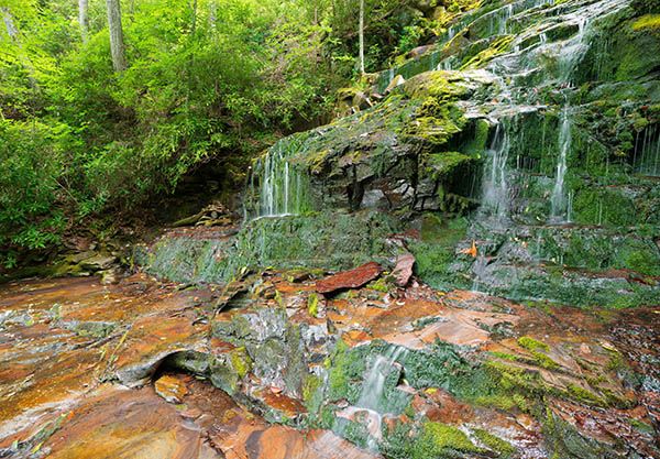
The first time I saw this waterfall in 2015 was during a drought and the creek was barely a trickle. On my last visit in June 2025 the water flow was good, but the waterfall was covered in fallen trees, some of it still living. It’s quite a mess and really distracts from what is otherwise a very beautiful waterfall. The upper section is nearly fully hidden by the trees.
Another change is with the rock. On my first visit, much of it was covered in lush, green moss and the rest was brightly colored orange. On my recent visit the rocks and moss were all dark.
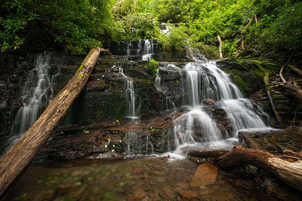
It’s still a nice falls, though, and when combined with Lower Bald Springs Falls (a short distance downstream) and Rain Forest Falls (a short distance upstream) it makes a great outing for the more hard-core waterfallers.
This is the view of the main upper section. There is lower section and also more falling water above. (034B-264579)
Driving Directions
Open driving directions in map appFrom the junction of NC 69 and US 64 in Hayesville, drive 4.8 miles west on US 64 and turn right on Fires Creek Road (SR 1300). Drive 3.9 miles and turn left on Fires Creek Wildlife Road (SR 1344) at the sign for Nantahala National Forest, Fires Creek Picnic Area. Fires Creek Wildlife Road changes to gravel at 1.7 miles, where it becomes FS 340.
At 0.1 mile on FS 340, you’ll pass by the picnic area, where Leatherwood Falls is located. Continue on FS 340 for another 7.1 miles to where the road makes a sharp left turn to swing around a ridge. GPS for this point is 35.127903, -83.783382. Park in the outside of the curve.
At my last visit in June 2025, FS 340 was gated 0.9 miles before the trailhead at the junction of FS 340 and FS 340C. The road was closed due to damage from Tropical Depression Helene. A sign here said there was no estimate for when it will be reopened. Also, on a previous visit, FS 340 was gated 2.7 miles before the trailhead at the junction of FS 340 and FS 386.
Hiking Directions
Quick Glance
Bushwhack straight down the broad ridge to the confluence of Bald Springs Branch and Fires Creek. Wade across Fires Creek and creekwalk up to Lower Bald Springs Falls, then continue upstream to Bald Springs Falls.
Detailed Look
If you’re coming here, I’m assuming you’re going to visit Lower Bald Springs Falls (downstream) and Rain Forest Falls (upstream), so I’m going to provide detailed info for all of them here.
Bald Springs Branch flows into Fires Creek directly at the bend where it flows around the broad ridge. The climb down from FS 340 is steep, but the forest is open and easily traversed. Crossing Fires Creek will likely be a wade, but you shouldn’t begin this hike expecting to keep your feet dry, anyway. Once across, it’s a short and relatively easy creekwalk up to Lower Bald Springs Falls.
To reach Bald Springs Falls, you’ll need to leave the creek to climb around Lower Bald Springs Falls. This is probably easier on the river-right side as there are small cliffs on river left. Once you reach the top of the falls, drop back down to the creek as soon as you can and continue upstream in the creekbed. The creek is wilder now, but still much easier to navigate than the rhodo tangles in the woods. You’ll soon reach Bald Springs Falls.
Leave the creek again to get around Bald Springs Falls. I climbed up on river right, but river left might be just as easy. It’s steep, but not too bad if you’re used to bushwhacking. The creekwalk from Bald Springs Falls up to Rain Forest Falls is a little harder. When you get close, you’ll likely find it easier to escape the creek on the river-left side and bushwhack the remaining distance.
For the return, you have some decisions to make. You can backtrack, follow an old, overgrown road back down, or take a hiking trail back to FS 340. If you were able to drive all the way to the trailhead, you’ll likely want to choose one of the first two options, which would be the shortest route. I noticed on LiDAR imaging an old logging road on the river-left side that loosely parallels Bald Springs Branch and comes down near its confluence with Fires Creek. This road is only a few yards up the (very steep) bank at Rain Forest Falls, so you could climb up the bank and follow this road back down. While I haven’t done this, I can tell you that in the vicinity of Rain Forest Falls, the road is heavily overgrown. I would assume it is the entire way down.
If FS 340 is gated and you can’t drive all the way to the trailhead, it brings up the other option. Bald Springs Trail #78 is not too far up the slope from Rain Forest Falls. You could climb up to it and follow it down to FS 340. It comes to the road about 0.1 miles from its junction with FS 340C. On my recent trip, when FS 340 was gated at this point, taking Bald Springs Trail back was by far the easier and shorter route. Of course, I could have done the hike in reverse by hiking Bald Springs Trail first and then following the creek downstream, but I find it much easier and safer to creekwalk upstream rather than down.
Yet another option would be to use the old logging road to access all the waterfalls instead of doing any creekwalking. This might be a good option if the road wasn’t overgrown and you lucked out by dropping off the road at just the right spot for all three falls. I think the creekwalk is the best option.
| Accessibility: | Bushwhack and creekwalk |
| County: | Clay |
| River Basin: | Hiwassee |
| Watercourse: | Bald Springs Branch |
| Watershed: | Small |
| Type and Height: | Multi-ledge falls nearly 100 feet high Height measured with rangefinder. |
| Landowner: | Nantahala NF, Tusquitee RD |
| Beauty Rating: | 6 |
| Elevation: | 3100 feet |
| USGS Map: | Andrews |
| Hike Difficulty: | Difficult |
| Hike Distance: | About a quarter mile |
| Waterfall GPS: | 35.127306, -83.781021 Reading taken from the base of the upper section. There is a lower part below this. |
| Trailhead GPS: | 35.127903, -83.783382 The road may be closed to this point. See Driving Directions. |
Photo Gallery
Click a photo to enlarge.