Kalakalaski Falls #2
!
Overview of Kalakalaski Falls #1, #2, and #3.
Kalakalaski Falls was one of my early introductions to puzzling waterfall information. Nearly everything I read stated that the waterfall was a series of eighteen small falls downstream from Lake Sequoyah on Cullasaja River. The statement is still repeated today. A few other reports stated that Lake Sequoyah inundated the waterfall, a claim also repeated today. None of this is true.
I have no idea how one came up with “eighteen small falls.” There are three nice waterfalls and a bunch of cascades. Maybe somebody counted all the cascades and added them to the bigger guys, but even then, I don’t see how you could arrive at eighteen of them.
The inundation assertion is one I’ve seen at other lakes where it is believed that the dam partially or fully flooded a waterfall. But dams are built on top of waterfalls, not below. Anyone doubting this needed only to drive by Lake Sequoyah in 2015 when the town drained the lake for water intake and dam repairs.
The descriptions of Kalakalaski Falls often say that the eighteen falls lie between Lake Sequoyah and the old powerhouse near Bridal Veil Falls, a stretch of river spanning approximately half a mile. Given that the three significant waterfalls are spread far apart and the access for each is not the same, it would be cumbersome to treat them as a single waterfall. So, I have decided to assign number designations and to provide a separate listing for each one.
I mean this only for clarity. I have not heard of any other names for these waterfalls besides Kalakalaski or a variation of that name, and as far as I’m concerned, that name should apply to all of them. The #1, #2, #3 designations are meant only to let you know which part of Kalakalaski Falls I’m describing.
Immediately below the dam is Kalakalaski Falls #1. Kalakalaski Falls #2 and Kalakalaski Falls #3 are a good distance downstream, near the old powerhouse. Visiting Kalakalaski Falls #2 is not recommended, even for mountain goats (goat horns easily get caught in the dense rhodo tangles). I’ll provide all the information you’ll need should you choose not toheed my recommendation, but you have been warned.
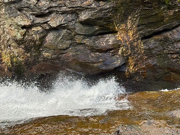
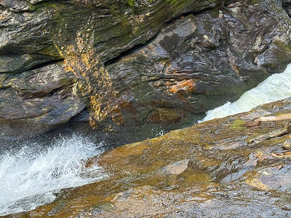
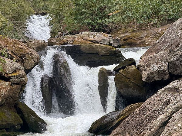
Despite my recommendation not to go, I have to admit that the waterfall is pretty cool. It starts as a cascade, then the entire force of Cullasaja river squeezes into a chute no more than four-feet wide. The problem is that there is no open and safe vantage point to see it.
Read the Cullasaja River section for an overview of the river and its waterfalls, including a list of landmarks with mile markers. You can find it by clicking the Little Tennessee River Basin button on the Rivers page.
This is not a very good view of the waterfall, but it's about as good as it gets from ground level. Cullasaja River roars through the cleft in the center of the image and then crashes steeply to the narrow pool. The photo doesn't show this very well, so don't let it fool you. This is a wicked place! (025B2-261953)
Driving Directions
Open driving directions in map appFrom the junction of US 64 and NC 106 in Highlands, drive 2.3 miles west on US 64 to Bridal Veil Falls.
Hiking Directions
Where do I start? I’ve bushwhacked the stretch from Lake Sequoyah downstream to the old powerhouse at least three times, the last one in February of 2025. I can state with 100% conviction that I will never do it again. It’s a miserable combination of steepness, rock scrambles, rhodo tangles, briers, and just plain nastiness. If there was a Class IV on my bushwacking rating system, this would be the poster child for it.
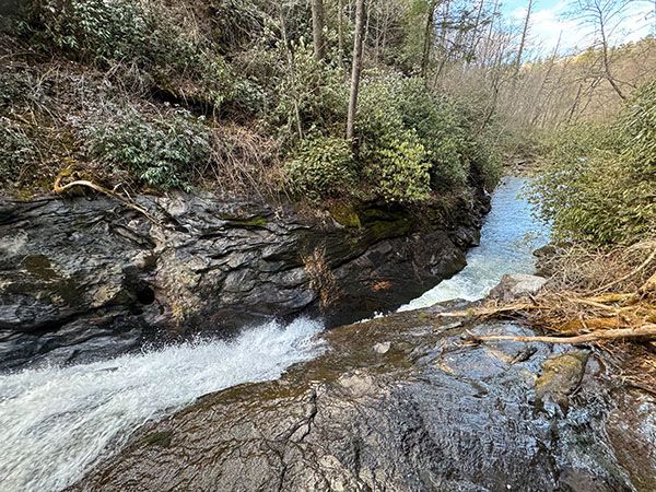
You can see the lower section of the waterfall from the viewpoint for Kalakalaski Falls #3. It doesn’t look very far upstream from it, but it’s farther than it looks. I recommend stealing a glance from there and getting the heck out of there.
Quick Glance
Not giving you a quickie for this one.
Detailed Look
The first part of the hike is the same as Kalakalaski Falls #3. Walk about 100 yards on US 64 toward Highlands. (Be careful on this busy road.) The path off the road should be obvious if you pay close attention. It starts right beside a power pole that has number 80 on it. The path descends steeply, mostly via stone steps, to the old hydro plant. To view Kalakalaski Falls #3, scramble along the riverbank up to a viewpoint a short distance from the power plant.
To reach Kalakalaski Falls #2, you’ll need to climb up and around the cliffs. Once you get around, there is only one vantage point from which you have a modest view of the lower section of the falls and the chute, but it’s just not safe climbing down to it. If you insist, I strongly recommend bringing a rope and knowing how to use it.
More wicked bushwhacking brings you up and around to the upper cascade that begins the falls. From here you have a decision to make. You could continue following the river upstream to Kalakalaski Falls #1, or you could climb straight up the slope to US 64. Although the latter is difficult as hell, it is by far the better option. It will be much farther than you think following the river up, and the entire route is just more of the same nastiness you went through to get here. If your goal is to see Kalakalaski Falls #1 from the base, you would be much better off climbing down from US 64 near the falls.
| Accessibility: | Class III Bushwhack |
| County: | Macon |
| River Basin: | Little Tennessee |
| Watercourse: | Cullasaja River |
| Watershed: | Medium |
| Type and Height: | 35-foot cascade and drop through a narrow chute Height measured with rangefinder. |
| Landowner: | Nantahala NF, Nantahala RD |
| Beauty Rating: | 5 |
| Elevation: | 3455 feet |
| USGS Map: | Highlands NC/GA |
| Hike Difficulty: | As hard as it gets! |
| Hike Distance: | Approx. 0.3 mile |
| Waterfall GPS: | 35.069189, -83.229202 Reading taking from a point about midway on the falls. |
| Trailhead GPS: | 35.07221, -83.22906 The trailhead is at the parking area for Bridal Veil Falls and is the same for Kalakalski Falls #3. |
Photo Gallery
Click a photo to enlarge.