
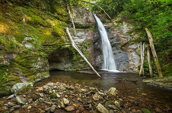
Middle waterfall on Chestnut Creek
!
This waterfall is not far downstream from Chestnut Falls. It’s very similar to the nearby Courthouse Falls, dropping into a little amphitheater of sculpted rock. It’s strictly for hard-core waterfallers who are okay with tough bushwhacks.
(022C1-252444)
Driving Directions
Open driving directions in map appThe trailhead is the same as Courthouse Falls and the upper waterfalls on Courthouse Creek, Cody Falls, and all the waterfalls on Chestnut Creek. From Beech Gap on Blue Ridge Parkway, drive 6.65 miles south on NC 215 and turn left on the gravel FS 140 (Courthouse Creek Road). FS 140 is 10.4 miles north of US 64. Follow the road for 2.5 miles to the gate and park in the cleared area on the left. This trailhead is 0.2 miles farther on FS 140 than the trailhead for Kiesee Falls and Upper Kiesee Falls.
Note that as of this writing, FS 140 is closed indefinitely. If it is closed when you visit, you’ll have to park in the area beside NC 215, across from FS 140, and walk the road.
Hiking Directions
Quick Glance
Hike 0.1 miles on FS 140, turn right on FS 5031, hike 0.8 mile to a fork, and take the path on the left that leads down to Chestnut Falls. When you reach Chestnut Creek, follow it downstream to the top of the falls, then swing wide around on river right to reach the base.
Detailed Look
There are a few ways to reach this waterfall, none of them easy. I got there by hiking first to Chestnut Falls, then following the creek downstream. I stayed mostly in the creekbed until I got close to the top of the falls, then I swung around on river right to reach the base. That part was an especially tough doghobble wade. Whether you go river right or river left, you must swing wide to avoid the cliffs around the falls, then creekwalk back up to the base.
After viewing this waterfall, I continued downstream to the lower waterfall. After that, I followed the creek downstream to FS 140. This was much easier than retracing my steps would have been.
To reach Chestnut Falls, walk past the gate on FS 140 and continue about 0.1 miles to FS 5031 (Kiesee Creek Road) on the right. Follow FR 5031 on a moderate uphill grade. Whenever you come to a fork or a road turning right, go left on the more obvious road. You’ll top out and begin a gradual descent along a narrow ridge. Continue staying to the left at any junctions. At a little over 0.8 miles from FR 140, you’ll come to a fork at a grassy area. Look for a path entering the woods on the left. It may be a little hard to find but look around and you should see it. The path leads several hundred feet to Chestnut Creek near the waterfall. The path is overgrown and has several fallen trees over it.
| Accessibility: | Hiking trail and Class III bushwhack |
| County: | Transylvania |
| River Basin: | French Broad |
| Watercourse: | Chestnut Creek |
| Watershed: | Small |
| Type and Height: | Very steep sliding and freefalling falls, 35 feet high Height measured with rangefinder. |
| Landowner: | Pisgah NF, Pisgah RD |
| Beauty Rating: | 6 |
| Elevation: | 3670 feet |
| USGS Map: | Sam Knob |
| Hike Difficulty: | Difficult |
| Hike Distance: | Approx. 1.25 miles |
| Waterfall GPS: | 35.27728, -82.887351 |
| Trailhead GPS: | 35.269447, -82.8891 |