Waterfall at Cape Fear River Trail Park
!
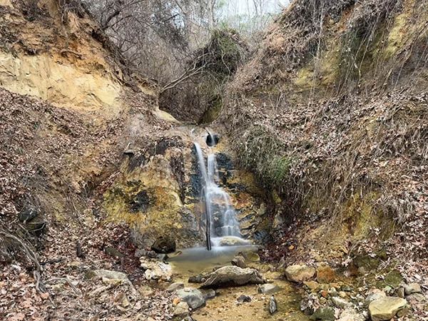
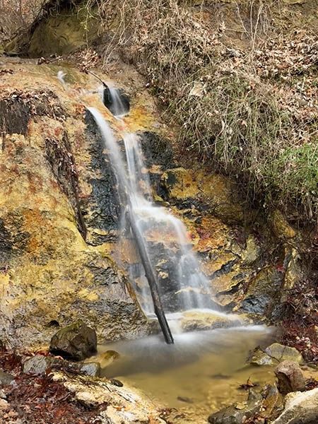
It’s only 12 feet high and in a little canyon full of old tires, chunks of concrete, and a never-ending fresh supply of beer cans. I suspect most people wouldn’t give it a second glance, if they would even give it a first one. But for some reason that I can’t fully explain, I really like this waterfall.
First, it’s located where no waterfall has any business being. Sure, it’s on the Fall Line, where the harder rocks of the Piedmont give way to the softer sedimentary rocks of the Coastal Plain. But typically, when one thinks of Fall Line waterfalls, they are on the larger streams like Cape Fear River. Fall Line waterfalls on those rivers are more like rapids and rarely have vertical drops of any height. In fact, the tiny stream here flows into Cape Fear River only a few yards downstream from the falls and on the Cape Fear at that point is Smileys Falls, which falls—get ready—a whopping 20 or so feet in a couple miles!
Another thing I like about it is the little canyon it’s in. That’s something else you don’t find often in this region, but here it is, a 35-foot-deep gully on an itty-bitty creek.
Finally, the waterfall is rather pretty if you can view it in isolation and ignore the trash and weeds around it. And the creek below flows into a scenic section of Cape Fear River, adding to the appeal.
(014F-260517)
Driving Directions
Open driving directions in map appThe trailhead is the same as Smileys Falls. Cape Fear River Trail Park is on the river-left side of the river at the NC 217 bridge. The address is 1002 S. 13th Street, Erwin.
Hiking Directions
Quick Glance
Follow the path from the parking area upstream as far as you can go. Walk around the fence to the edge of the canyon to view the falls from above. To see it from the base, climb down the back to the left of the viewing deck and work your way upstream.
Detailed Look
Follow the path 0.2 miles from the parking area upstream to the factory building. Walk the path behind the building for 0.15 miles to the Dunn-Erwin Rail-Trail, which turns right. Stay with the river, continuing straight, and reach Overlook 3 in less than 0.1 miles. A few yards ahead, behind the fence, is the small canyon and the view of the falls from above.
There is a makeshift path to the left of the overlook. It descends steeply to Cape Fear River. Upstream a few yards is a nice view of the river and the mouth of the canyon with the waterfall. To see it, follow the little stream upstream for a short distance.
Near the parking area are several overlooks and a path that leads down to the river. Click here for a map.
| Accessibility: | Path, bank scramble, creekwalk |
| County: | Harnett |
| River Basin: | Cape Fear |
| Watercourse: | Tributary of Cape Fear River |
| Watershed: | Very small |
| Type and Height: | 12-foot-high freefalling and cascading falls |
| Landowner: | Appears to be owned by the Town of Erwin |
| Beauty Rating: | 3 |
| Elevation: | 90 feet |
| USGS Map: | Erwin |
| Hike Difficulty: | Easy/difficult |
| Hike Distance: | About half a mile |
| Waterfall GPS: | 35.320432, -78.693935 |
| Trailhead GPS: | 35.3135, -78.691332 |
Photo Gallery
Click a photo to enlarge.