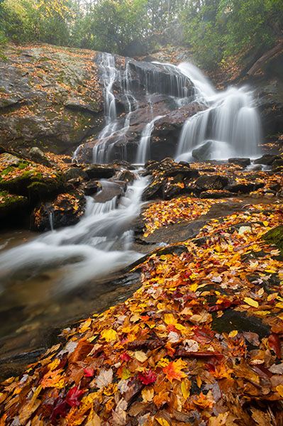
Upper Dill Falls
!
Most people who drive out here come to see Dill Falls, an impressive and easily reached waterfall. Few of them know that another scenic waterfall lies just a few yards upstream, though getting to it requires considerably more effort.
Upper Dill Falls is about a quarter as tall as its downstream sibling, but its delicate, broken flow gives it a scenic appeal that in some ways exceeds the lower falls.
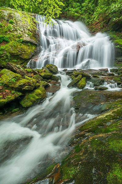
Upper Dill Falls. (028E-101584)
Driving Directions
Open driving directions in map appThe trailhead is the same for Dill Falls and Upper Dill Falls.
From Beech Gap on the Blue Ridge Parkway, drive 2.65 miles south on NC 215 and turn right onto the gravel FS 4663. The road is easy to miss and may look like a driveway. If you’re coming from US 64 near Rosman, drive 14.4 miles north on NC 215 and turn left onto FS 4662.
Continue 1.9 miles on FR 4663, then bear left onto FS 4663B. The turn may seem a little sketchy, but it’s okay. Follow FS 4663B for 0.55 miles to its end.
Note: FS 4663 has a gate 0.6 miles in and it’s typically closed from December 15 to March 15.
Hiking Directions
Quick Glance
Hike the ascending old road to an obvious side path on the left, which leads to the base of the falls.
Detailed Look
As you approach the end of FR 4663B, you’ll see two old forest roads on the right. The one cutting sharply right that ascends is the access for Upper Dill Falls. The other one is very close; it descends and looks more like a trail. That’s the one for Dill Falls.
Hike the old ascending road and reach the crest of the ascent in a little over 200 yards. In another 175 feet, turn left on the obvious side path turns left. The path descends steeply for less than 200 feet to the base of the falls.
Other Hiking Options
If you want to see Upper Dill Falls and Dill Falls on the same hike, and you’re good with bushwhacking, from Upper Dill Falls you can swing away from the brink of the lower falls and descend the steep bank on river left to the base. As long as you stay away from the waterfall on the descent, this is about as easy as the hike down to the base of the upper falls. From the base of the lower falls, follow the old road back to the trailhead to complete the loop.
| Accessibility: | Hiking trail |
| County: | Jackson |
| River Basin: | Little Tennessee |
| Watercourse: | Tanasee Creek |
| Watershed: | Small |
| Type and Height: | Cascading and freefalling falls, 23 feet high Height estimated from LiDAR map. |
| Landowner: | Nantahala NF, Nantahala RD |
| Beauty Rating: | 6 |
| Elevation: | 4160 feet |
| USGS Map: | Sam Knob |
| Hike Difficulty: | Difficult |
| Hike Distance: | 0.2 miles |
| Waterfall GPS: | 35.28397, -82.94324 |
| Trailhead GPS: | 35.28274, -82.94092 |
Photo Gallery
Click a photo to enlarge.