
Upper Kiesee Falls
!
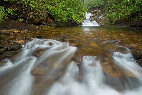
Although small, this waterfall is scenic and has one of the most inviting swimming pools I’ve seen. It’s also a good photo subject, with a nice little cascade at the lower end of the pool to include in the foreground.
From the pool, you can look downstream and see the brink of Kiesee Falls. However, because of the steep rock walls surrounding the falls, you can’t get to it safely from here. It may be possible to negotiate the rock on river right, but I don’t recommend it. Even if you make it down safely, you’ll likely destroy a lot of vegetation doing so.
(022I-126940)
Driving Directions
Open driving directions in map appFrom Beech Gap on Blue Ridge Parkway, drive 6.65 miles south on NC 215 and turn left on the gravel FS 140 (Courthouse Creek Road). FS 140 is 10.4 miles north of US 64. Follow the road for 2.3 miles to a sharp left turn and park here. This is 0.2 miles before reaching the gate and the trailhead for Courthouse Falls and Chestnut Falls.
Note that as of this writing, FS 140 is closed indefinitely. If it is closed when you visit you’ll have to park in the area beside NC 215, across from FS 140, and walk the road.
Hiking Directions
Quick Glance
No quickie for this one.
Detailed Look
At my last visit in August 2020, logging was occurring on the uphill slopes at the trailhead and areas of flagging tape that I suspect were associated with the logging were in the uncut woods along the hike. I wrote these directions right after this hike, the logging activity could have caused them to be inaccurate. Also, things could have changed now that the forest has began recovery.
An obvious road created by logging bulldozers starts from the curve in FR 140. Follow this road through the logged area and into the uncut woods. Once you leave the logged area the road is overgrown somewhat, but easily followed.
The road forks at 0.26 mile (35.27402, -82.88442). Go right on the lower path. At 0.48 miles, another old road bears right (35.27670, -82.884426). This is the route to Kiesee Falls. For Upper Kiesee, you want to go left.
After about 0.25 miles, you’ll cross a wet-weather branch with a tiny waterfall on the upstream side of the trail. A few yards beyond this branch, look for a makeshift path that descends off the right side of the trail (35.279518, -82.882245). The path descends a few hundred feet to the creek. When you reach the creek, you’ll have to negotiate a short, steep, sloping rock. If it’s icy or covered in wet leaves, you’ll need a rope to make it down safely.
| Accessibility: | Hiking trail |
| County: | Transylvania |
| River Basin: | French Broad |
| Watercourse: | Kiesee Creek |
| Watershed: | Small |
| Type and Height: | Upper drop through a little chasm and lower cascade into a pool; the total drop is about 16 feet Height estimated. |
| Landowner: | Pisgah NF, Pisgah RD |
| Beauty Rating: | 6 |
| Elevation: | 3520 feet |
| USGS Map: | Sam Knob |
| Hike Difficulty: | Moderate+ |
| Hike Distance: | About 0.8 miles |
| Waterfall GPS: | 35.27936, -82.88178 |
| Trailhead GPS: | 35.27126, -82.88785 |