
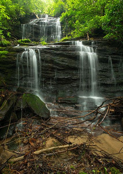
Upper waterfall on Wolf Creek tributary below Lauren Falls
!
For the full scoop on this waterfall, you should also read the page for Lower waterfall on Wolf Creek tributary below Lauren Falls. I like the lower falls much better, but oh my, what a wicked hike it is getting there.
I checked out this creek many years ago when I found Patricia Falls and Lauren Falls. But it was dry, and I didn’t bother climbing up to see a big damp rock. In the years since, a few people have told me about it, including one who sent me a LiDAR screenshot. I’m sorry for not remembering your names. Mark Morrison also includes the two waterfalls in his latest Waterfall Walks and Drives guidebook.
So, I finally explored the entire creek in June 2025. At my age, I know there are many waterfalls in North Carolina that I will never see again in person. It does not hurt my feelings that this is one of them.
There are two reasonable options for visiting these waterfalls, the difficulty level being much higher if you see both on the same hike. I’ll explain both routes in Hiking Directions.
(028B2-264456)
Driving Directions
Open driving directions in map appThe trailhead for the lower route is at Balsam Lake Recreation Area on Charleys Creek Road (SR 1756). From the east, turn off NC 215 onto Charleys Creek Road, 3.2 miles south of Blue Ridge Parkway. Follow Charleys Creek Road 5.3 miles to Balsam Lake. From the west, you can access Charleys Creek Road from NC 281, some 8.4 miles south of NC 107. From that direction, it is 5.4 miles to Balsam Lake.
The trailhead is the same for Balsam Lake Dam, Balsam Falls, Lower Balsam Falls, Patricia Falls, Lauren Falls, and the waterfall below this one.
Hiking Directions
The two waterfalls on this stream are close together. But between them is a hellish nightmare of dog hobble, little cliffs, briars, and leg-breaking holes. The shortest and easiest route to the upper falls is to start off Charleys Creek Road and bushwhack to it. But if you also wish to visit the lower falls, the idea of climbing down to it and then backtracking is not very pleasant, especially considering that if you returned by the lower route you’d get to see the really nice waterfalls on Wolf Creek. With that said, if all you care to do is see these two waterfalls, coming in from above may be the easier route.
For me, the better route by far is to start at Balsam Lake Recreation Area and hike to all the falls on Wolf Creek, then follow this tributary upstream to both falls, then bushwhack out to the Charleys Creek Road and walk it back to your car. With either option, you’ll need to use a map app that shows property lines to get you legally from the upper falls to the road, or vice versa. And I’m going to leave it to you to determine where to start or come out on the road. Honestly, if you can’t figure all that out, you don’t need to be making this hike.
Detailed Look For the Lower Access
If you start at Balsam Lake Recreation Arae, here’s a play by pay for you.
Cross Wolf Creek on the footbridge and follow the trail to the dam. Right at the dam is an obvious, but unofficial path heading downstream. It’s not graded but easy to follow. When you reach Balsam Falls, you’ll see the short, steep scramble path to the base. Be careful, especially if you wade out into the pool.
The old route to the lower waterfalls required wading across the pool below Balsam Falls, which is right at the brink of Lower Balsam Falls. Thankfully, there is now a much better route, created by enough waterfallers who didn’t relish the wade. After viewing Balsam Falls, climb back up to the path and continue following it downstream.
his part of the path is a little difficult, but at least it’s not a bushwhack. It comes out at the downstream end of the pool below Lower Balsam Falls. You must cross the creek here, but this is a piece of cake compared to crossing above the falls. You’ll probably want to find a spot a few feet downstream from where the path comes to the creek.
There is a tiny island here that has two medium-size trees growing on it. Walk to the upstream end of the island, hop across the tiny channel, and climb up the bank. It looks sketchy, but shouldn’t be a problem if you’ve made it this far. The rough path ascends steeply to meet the old path coming down from Balsam Falls. Head downstream on it.
The path is overgrown in places but if you follow the route of least resistance, you should be able to remain on it. If not, no worries. Just head downstream and work your way to the creek. The path does just that and then follows closely along the creek.
After crossing a small side stream, look for a good place to cross Wolf Creek. The brink of Patricia Falls is just around the bend and a ridge comes down to the creek on the other (river-left) side. The old route to the base required hiking up a short distance on the ridge, then turning to the right and descending a hellish route on the steep rock face. Fortunately, there’s now a better way.
After crossing the creek, look for a path that climbs up the bank and heads up the ridge. You’ll quickly come to the old route that turns right. Keep going straight and follow the relatively new route that circles above the hellhole before dropping down to the falls. It’s not easy by any definition, but at least it’s not suicidal.
Lauren Falls is only a few yards downstream from Patricia. The old route to it competed with the old route to Patricia for the most “This can’t be right” comments from hikers. But sometime between 2019 and 2025, someone built a new trail between the two falls. It’s a decent trail, with cut trees, stone steps, and grading. Imagine my delight in finding this!
When you get close to Lauren Falls, a side path turns to the right and deposits you at the base of the falls. For the best view, you’ll want to cross the river-left division of the creek to get to the little island and walk up to the edge of the pool.
From the side path to Lauren Falls, the trail continues following Wolf Creek downstream. In less than a quarter mile, you’ll see a scenic little creek-wide waterfall. You need to climb down the bank above this falls, cross the creek, and walk a short distance upstream to the little cascades. The tributary enters Wolf Creek at this point.
From here, you’ll just follow the creek upstream. If you stay close to the creek, you’ll see the lowermost drop, which is maybe 20 feet high. It isn’t very exciting but if you’re going to all this effort, you might as well see all you can. For the big guy, it’s best to swing wide around on river right and come back to it. It’s a tangled mess close to the creek.
For the upper falls, you need to swing wide around to avoid the little cliffs and as much of the nastiness as possible. Once you reach the falls, you’ll need to cross over to the river-left side and bushwhack from there to the road. Thankfully, the bushwhack from the falls to the road is much easier than it is along the creek. Remember, there are private property lines to avoid, and you’ll need to be proficient at using map apps to navigate, as there are no streams or other landmarks to guide you.
| Accessibility: | Class III bushwhack |
| County: | Jackson |
| River Basin: | Little Tennessee |
| Watercourse: | Tributary of Wolf Creek |
| Watershed: | Very small |
| Type and Height: | Multilevel falls measuring 45 feet high Height measured with rangefinder. |
| Landowner: | Nantahala NF, Nantahala RD |
| Beauty Rating: | 3 |
| Elevation: | 3640 feet |
| USGS Map: | Sam Knob |
| Hike Difficulty: | Difficult Difficult if you hike from the road and backtrack. As hard as it gets if you also visit the lower falls. |
| Hike Distance: | Approx. !.5 miles This is if using the lower route. It is less than 0.5 mile one-way using the upper route. |
| Waterfall GPS: | 35.263438, -82.972071 |
| Trailhead GPS: | 35.272925, -82.969369 |