
Waterfall on tributary 1 of Horsepasture River
!
Wanna know one of the worst feelings a waterfaller can have? It’s not when a highly anticipated waterfall disappoints but when you make a lot of effort to visit a disappointing waterfall, cross that sucker off the list for good, then later learn that you didn’t see all the waterfall and now you have to go back do that miserable hike again.
You know where this is going, right?
I learned about this waterfall many years ago from waterfalling guru Bernie Boyer. Bernie sent a pic of what he called the lower falls and one of the upper falls. Like the idiot that I can be sometimes, I left those photos behind on my last visit in February 2026. I got to the creek and thought I was seeing the lower falls, so I scrambled up to what I thought was the upper falls.
When I got home, I saw that I had only climbed up to what Bernie was calling the lower section. Studying LiDAR confirmed that there is indeed another section upstream.
The part I saw could be a decent waterfall, I think, but it’s so hemmed in by trees and rhododendron and so covered with fallen branches and trees that all you see is a big mess. And it’s on a very small stream, so you can barely see any water through all this clutter.
Does the upper section look any better? Honestly, I doubt it. It certainly does in Bernie’s photos, but that was long ago and there have been some major storms since then. I can’t imagine the upper part is any clearer than the lower. But, dang it, I’ll go back sometime and check it out.
It’s hard to talk about this waterfall without mentioning several other waterfalls close by. On the trail to here, you pass a side path that provides access to Stairway Falls and Sidepocket Falls. A little farther along the trail from the turnoff to this waterfall is a short side path to Hidden Falls. Upstream from Hidden is the incomparable Rainbow Falls, which is a very short distance downstream from Turtleback Falls. A little above Turtleback is Drift Falls. I’ll be mentioning all these to some extent on this page.
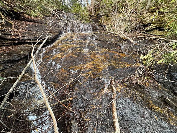
This is as good as it gets for the lower section. Hopefully the upper part is nicer. (060P-270195)
Driving Directions
Open driving directions in map appThe trailhead is the same for Rainbow Falls, Turtleback Falls, Drift Falls, Hidden Falls, stairway falls, Sidepocket Falls, and Waterfall on tributary 1 of Horsepasture River.
From US 64, drive south on NC 281 for 0.9 mile and turn left at the entrance for Gorges State Park. Drive 0.95 mile to a stop sign at the visitor center. Turn left and drive 0.8 mile to the Grassy Ridge Parking Area, on the right.
Hiking Directions
I’m providing directions here for all the major waterfalls accessed from Rainbow Falls Trail except Stairway Falls and Sidepocket Falls. This includes Hidden Falls, Rainbow Falls, Turtleback Falls, and Drift Falls.
Quick Glance
Hike the trail from the kiosks to a T-junction. Turn right and follow the trail to Rainbow Falls, then Turtleback Falls, then Drift Falls. Hidden Falls is accessed by a short side path downstream from Rainbow Falls.
To see Waterfall on tributary 1 of Horsepasture River, at the second creek crossing, walk behind the campsite and follow old overgrown road to the creek at the bottom of the falls.
Detailed Look
Begin at the kiosks at the far end of the parking area. At 0.3 miles you’ll reach a T-junction. Turn right on the orange-blazed Rainbow Falls Trail. Descend moderately for about 0.4 miles to an easy creek crossing. At about 0.1 miles from the creek, you’ll see trail signs indicating that you’re leaving Gorges State Park. The remainder of the hike will be in Pisgah National Forest.
At a quarter mile from the creek crossing, the trail makes a sharp right turn, with a side trail on the left. (This side trail descends to Stairway Falls and provides access to Sidepocket Falls.) A little over 0.1 miles farther you’ll come to another creek crossing. This one is larger and requires a rockhop (easy) or a shallow wade if the water’s up. A few yards beyond the creek is a campsite on the right.
Behind the campsite is an overgrown forest road leading to Waterfall on tributary 1 of Horsepasture River in a little over 0.1 miles. You reach the creek at the bottom of the falls and must scramble up along or in the creek to see all of it.
Back at the campsite and continuing the main trail, Horsepasture River becomes a close companion. You’ll make a short, steep ascent, then descend, then go on a long moderate ascent. At about 0.3 miles from the creek crossing, you’ll come to an obvious side path on the left. This path descends a short distance to the river with a view of Hidden Falls upstream. Stay on the main trail for a better view. In another 200 feet you’ll come to another side path. This one descends to a much better and closer view of the falls.
From this side path it’s a steep climb for a little over 0.1 miles to an open view of Rainbow Falls at a split-rail fence. The trail forks at the far end of the fence. The path to the left descends to a lower observation area for the falls. Take the right fork to continue the hike. You’ll reach a point near the top of Rainbow Falls in less than 0.1 miles. A fence is here, designed to keep you on the main trail and away from the top.
| Accessibility: | Hiking trail & Class III bushwhack |
| County: | Transylvania |
| River Basin: | Savannah |
| Watercourse: | Tributary of Horsepasture River |
| Watershed: | Very small |
| Type and Height: | Sliding, cascading, freefalling waterfall, perhaps 105 feet high Height estimated from LiDAR map. |
| Landowner: | Pisgah NF, Pisgah RD |
| Beauty Rating: | 1 |
| Elevation: | 2720 feet |
| USGS Map: | Reid NC/SC |
| Hike Difficulty: | Difficult |
| Hike Distance: | 1.3 miles |
| Waterfall GPS: | 35.089901, -82.958345 Coordinates are at the base of what I thought was the upper section. |
| Trailhead GPS: | 35.088764, -82.95187 |