
Waterfall 2 in Possum Hollow
!
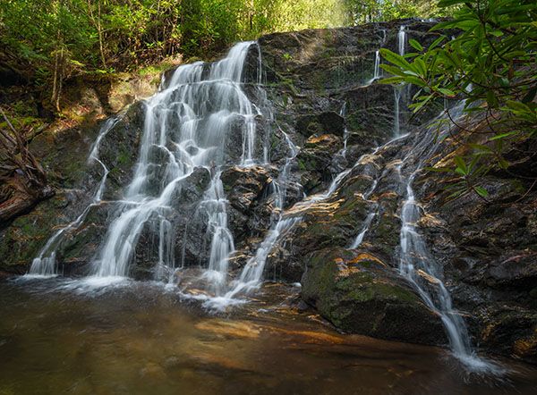
The difficult bushwhack to this one will be well rewarded. The scenic waterfall drops in two sections into a small pool. At the top of the main lower section, another stream flows in from the river-left side and at the confluence it adds its own little waterfall. To see the upper falls you’ll have to climb up alongside the lower section.
The waterfall is located upstream from Waterfall1 in Possum Hollow, so you’ll get to see two falls on the hike.
(101Z4-270271)
Driving Directions
Open driving directions in map appThe trailhead is at Haywood Gap at Milepost 426.5 on Blue Ridge Parkway. The gap is about 3.3 miles south of Beech Gap, where NC 215 goes under the parkway.
Hiking Directions
Quick Glance
Walk a few yards northeast from the parkway and turn left at the trail junction. Follow the trail down to the first creek coming in on the left. Climb the river-left bank of the creek and follow the narrow path as far as you can. Waterfall 1 is a short distance farther upstream. For Waterfall 2, climb up the slope and pick up the old logging grade and follow it as best you can to the falls.
Detailed Look
Mountains -to-Sea Trail crosses Blue Ridge Parkway at Haywood Gap. Follow the trail on the northeast side of the parkway. (Right side of road if you’re traveling south from Beech Gap.) In 200 feet you’ll come to a trail junction. MST goes to the right. Turn left on Haywood Gap Trail.
You’ll soon enter Middle Prong Wilderness. After hiking for about three quarters of a mile, you’ll come to a creek crossing below a small waterfall. Cross the creek and climb up the river-left bank. You should be able to pick up a makeshift path that follows the creek upstream. The path takes you close to Waterfall 1. You’ll need to bushwhack the rest of the way to it.
To reach Waterfall 2, climb the slope from the end of the path and pick up the old logging grade. It’s heavily overgrown in places and has washouts, but if you follow the route of least resistance, you’ll be on it much of the way. It will be obvious when you reach the falls, at which point you must climb down the steep bank to reach a viewpoint at the base.
| Accessibility: | Hiking trail & Class II bushwhack |
| County: | Haywood |
| River Basin: | French Broad |
| Watercourse: | Tributary of Haywood Gap Stream |
| Watershed: | Small |
| Type and Height: | 30-foot cascading falls dropping in two sections Height measured with rangefinder. |
| Landowner: | Pisgah NF, Pisgah RD |
| Beauty Rating: | 6 |
| Elevation: | 4950 feet |
| USGS Map: | Sam Knob |
| Hike Difficulty: | Difficult |
| Hike Distance: | Approx. 1.1 miles |
| Waterfall GPS: | 35.320821, -82.954572 |
| Trailhead GPS: | 35.31358, -82.95394 |
Photo Gallery
Click a photo to enlarge.