
Logging
!
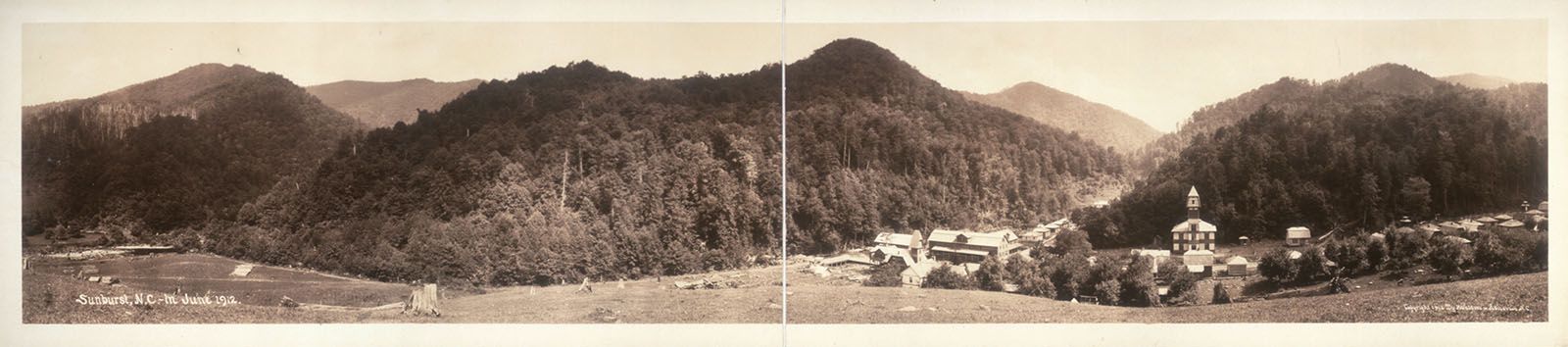
Panorama of the original Sunburst logging town at the jucntion of Middle Prong and Right Prong of West Fork Pigeon rivers. Photo by Herbert W. Pelton dated June 1912. Sunburst Falls is named for town. (M-005)
At first thought, you may be wondering what logging has to do with waterfalls. The answer is a lot! Let’s dig in and explore how the logging industry has had a profound effect on not only North Carolina’s waterfalls, but also how we visit them.
Logging in North Carolina has been going on since the first Europeans landed in the New World. Even before then, Native Americans cut trees, though on a vastly smaller scale compared to what was to come. The major period of logging operations in North Carolina occurred in the late 19th Century and first half of the 20th Century. This is when nearly all the old growth forests of the Appalachians were cut.
What was the effect on waterfalls? Let’s examine six different ways that logging has impacted North Carolina waterfalls.
Naming
I have little doubt that several of the waterfall names we use today were given by loggers, although I can’t give many examples with certainty. I do know for certain that some waterfalls were named because of logging, even if those names didn’t come from the loggers themselves. As a group, loggers likely saw more North Carolina waterfalls than anyone, except perhaps the most prolific waterfallers of today. Surely, they named some of them, with some of those names still being used.
The following North Carolina waterfalls have names that were either given by loggers or were named because of logging. These are only the ones I can say with certainty, but I would expect there to be many more.
Camp 2 Falls. Named for the old logging camp at the falls. This is a modern name, not given by loggers.
Logging Road Falls. An old logging road provides access to this waterfall. This is a modern name, not given by loggers.
Sheep Head Falls. I’m assuming that loggers named this waterfall since it is listed on a historical map showing the logging operations in the area.
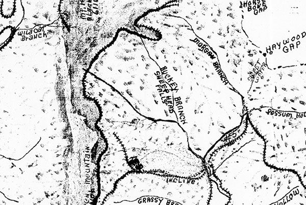
Crop from a large historical map of logging in the Shining Rock and Middle Prong regions showing Sheep Head Falls on Buckeye Creek. (101T-01)
Splash Dam Falls. Named for the splash dam that was built upstream from the waterfall. See Ecosystem Destruction below for more on splash dams.
Sunburst Falls. Named for the Sunburst logging town down the road from the falls.
Water Quality
There were no environmental controls guiding early logging in North Carolina, or anywhere else for that matter. Cut the trees, get the logs out, move on to the next stand—that was the business plan. With the mountainsides stripped, slash left lying where it was cut, and no erosion controls in place, floods and fires were commonplace. Every rain produced more runoff choking the streams.
This dire situation, occurring all over the country, was a principle factor in the creation of the Weeks Act, signed into law in 1911 by President William Howard Taft. The law authorized the federal government to purchase private lands in order to protect the watersheds of rivers. Incidentally, the first purchase made under the act was the 8,100 acre Curtis Creek track in Pisgah National Forest.
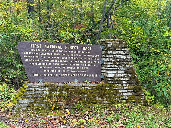
Historical marker at entrance to the Curtis Creek section of Pisgah National Forest. (066B-252502)
Pollution is still a problem in many North Carolina streams, but the water-quality issues created by large-scale logging are vastly improved. And with most of the stripped mountainsides now reforested, the streams run clear.
Ecosystem Destruction
Water quality could be included here, but I wanted to differentiate the physical destruction of the waterfall ecosystem that occurred from early logging. Of course, logging by definition is a destructive process. Regardless of how many environmental controls are in place, a clearcut is a clearcut, and that section of the forest is destroyed. But the logging practices of the early 20th century did more than just remove trees from the land. They had a major effect on not just the forest, but the land as well. Some of these effects are still seen today.
To get the logs out of the woods, loggers generally used one of four methods, beginning with mules or oxen, then watercourses, then trains, and finally trucks, although the first three overlapped. The problem with watercourses in western North Carolina is that most of them aren’t large enough to float a big log and they are full of waterfalls and cascades. To overcome these obstacles, loggers employed splash dams.
A wooden dam was constructed on the watercourse, often at the top of a waterfall or cascade. The impoundment held the logs for a period, usually until the streams were running at their highest. When the dams were opened, the logs and water rushed down the stream. Often, smaller splash dams were constructed on tributaries to add more water to carry the logs from the main dam.
Imagine the destruction caused when the rush of logs and water crashed down the stream. Streambeds and streambanks were scoured. Just getting the logs to the impoundment caused extensive damage from dragging the logs and letting them roll and slide down the slopes. Some of these scars are still visible today. And this isn’t even considering the damage caused by the bodies of water impounded for months by the dams.
Many splash dams occurred across North Carolina, and I would expect several of the waterfalls on this site to have been on streams where they existed. One that I know of for certain is Splash Dam Falls, named for the splash dam that was built upstream from the waterfall. In Glenville and Cashiers, From the Records, Carol M. Bryson quotes a newspaper article stating that two splash dams were built on West Fork Tuckasegee River above High Falls.112
Have to say, when I picture a pond full of logs going over High Falls on WF Tuck, all I see is a pile of toothpicks at the bottom! Same for Splash Dam Falls.
Aesthetics
This one is obvious. While logging may not have changed the appearance of a waterfall itself (hundreds of massive logs crashing over them after a splash-dam release notwithstanding), the landscape surrounding the waterfalls certainly was altered. Old growth forests have been replaced with second or third growth.
An interesting sidebar is the fact that up until a few years ago, many western North Carolina waterfalls had huge, old eastern hemlock trees growing very near them. These trees were standing during the logging days, but hemlock wood was not very valuable and so any trees that were difficult to get to, like those growing beside a waterfall, were left alone. The tall, evergreen trees were visible at a distance and helped me pinpoint more than one waterfall. If I saw a big hemlock on stream, I knew there was a good chance there was a waterfall there. Bernie Boyer called them “sentinel trees” for this reason.
Sadly, the big hemlocks are gone, victim of the hemlock woolly adelgid and the choice not to prioritize their protection. See “Hemlock Horror” for more info.
Access
On the positive side, the logging industry is responsible for many of the Forest Service roads and hiking trails that we enjoy today. I don’t know the numbers, but I wouldn’t be surprised if old logging railroad grades, along with a few logging truck grades, make up more miles of official hiking trails in Nantahala NF and Pisgah NF than trails built from scratch. I know that’s the case if you add in the unofficial trails. Great Smoky Mountains National Park also has many miles of trails built on railroad grades, as do some of our state parks.
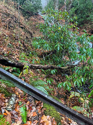
When I’m hiking a new trail, I like to look for indications that I’m walking along an old logging grade. Sometimes, it’s clearly evident, with old steel cables or railroad rails lying about. Pieces of coal are also good indicators, as coal was used to power the steam engines for the logging trains and skidders. More subtle indicators are a grade that doesn’t have sharp curves or very steep sections, and switchbacks where the grade extends beyond the switchback for several yards, the latter indicating a train switchback, where the train drove into a track on the outside of the switchback and then switched into reverse and backed up the slope (or the opposite if going downhill).
Sometimes you’ll find old cribbing from trestles or stonework at creek crossings, which served as foundations for bridges. My favorite thing to find is regular depressions in the trail that indicate where the railroad ties were. Yes, these exist! My guess is that they formed when the left-behind ties rotted away, causing depressions. It could also be from the depressions left behind when ties were removed, but it seems in that case the depression’s would have filled in by now. I don’t know; I just know they exist on several trails to waterfalls in western North Carolina, such as Flat Creek Falls in Nantahala National Forest.
Evidence Left Behind
As touched on in the Access section, evidence from the railroad logging days is everywhere, but I still find it noteworthy how much of it exists at waterfalls. I haven’t done a thorough job of exploring waterfalls specifically with this in mind, so I’m sure I’m missing some. But here’s what I know, or at least what I can remember.
Note that this list is only for artifacts at the waterfalls, not on the trails leading to them. Someday I may compile a list of waterfalls that are accessed by old logging grades, but that herculean effort will have to wait.
Little Bird Falls. Steel cables are on the waterfall and pieces of coal are at the base.
Mill Shoals. A railroad rail is mostly buried in the path near the falls.
Railroad rail at Mill Shoals.
Flat Laurel Creek waterfalls. Steel cables are in the creek a short distance upstream from the waterfalls.
Rock Slab Falls. The site of a former logging camp, you’ll find railroad rails at the bottom of the falls, iron pipes sticking out from the rock on the waterfall, and even an old axle and wheel from a train car.
Rough Butt Creek Falls. A railroad rail is in the pool at base of falls.
Sam Branch Falls. This one is borderline, since the artifact isn’t at the waterfall itself, but rather a few dozen feet up the bank from it. But it’s so intriguing that I have to mention it. On the narrow ridge of the river-left side is what looks like an old train car coupler. There was no railroad nearby to my knowledge, so how did this very heavy piece of metal get down here? It couldn’t have rolled down the mountain and it’s too heavy for someone to tote around on a whim. Very strange.
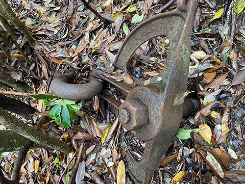
This artifact is very close to Sam Branch Falls, but far from where any logging train might have been located. (101H-200724)
Wolf Mountain Falls. There’s a railroad rail on the river-right bank beside the waterfall.
Logging railroad rail left behind at Wolf Mountain Falls. (028H-253155)