Marilou Bradley Falls
!
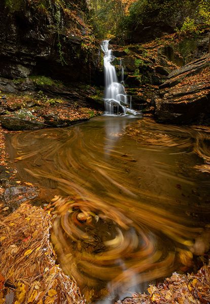
What this waterfall lacks in height it makes up for in character. Both sides have jagged cliffs, with the river-right side huge and imposing and overhanging a portion of the falls.
Marilou Bradley Falls. (002K3-117717)
Driving Directions
Open driving directions in map appThe trailhead is the same for Milton Bradley, Bradley Cooper, Marilou Bradley, and Cavern waterfalls. It is also the lower trailhead for Bradley Falls.
Take the Saluda exit (Exit 59) off I-26 and head east on Holbert Cove Road (SR 1142). After less than 0.1 miles, turn left on the curviest paved road in North Carolina, Green River Cove Road (SR 1151). Drive 3.75 miles and turn right on the dirt road just before the bridge over the Green River. A small sign is here for NCWRC Game Land Access Road. Drive past some buildings to reach a gate at 0.1 miles. Park here.
Hiking Directions
Quick Glance
Follow dirt road 1 mile to fork and turn left. Ford creek at 0.3 miles and enter fields. Walk to far right end of fields (0.4 miles from the creek crossing) and enter woods on path. Walk 200 yards to point near creek, then follow winding, makeshift path upstream 0.45 miles to Milton Bradley Falls. Climb path on river-right side of falls to top, then creekwalk about 0.25 miles upstream to Bradley Cooper Falls. To reach Marilou Bradley, you can follow the tributary upstream that flows into Little Cove Creek below Bradley Cooper.
Detailed Look
Follow the dirt road 1 mile to a fork. An old barn once stood in the corner, but it's now gone. Off the road to the right is an old shack. Turn left at the fork and hike the sandy road 0.3 miles to the Cove Creek crossing. Expect to wade. After crossing, the old road follows the creek upstream a short distance before turning sharply left and ascending to fields.
In summer, the route through the fields can be hard to follow. Basically, you want to work your way through to the far-right corner, which is 0.4 miles from the creek crossing. A path enters the woods here and leads 200 yards to a point close to Little Cove Creek. GPS for this point is 35.285661, -82.284931.
From this point, a winding makeshift path leads 0.45 miles upstream to Marilou Bradley Falls. The idea is just to follow the route of least resistance. At one point, you’ll likely need to walk in the creekbed for a short distance.
You must climb to the top of Milton Bradley. You may see a rope on the river-left side of the falls, but I no longer consider that an acceptable route. Now, there is an obvious path ascending the river-right side of the falls which provides a safer route to the top. However, that route comes out very close to the brink of the falls and you must be extremely careful.
Once at the top of Milton Bradley Falls, follow the creek about a quarter mile upstream to Bradley Cooper Falls. The rocks are extremely slippery. Just below Bradley Cooper, a tributary enters Little Cove Creek on river right. Marilou Bradley is a short distance upstream on the trib.
You can follow the trib upstream or take the path that climbs up the steep slope between Bradly Cooper and Marilou Bradley. It tops out and turns left towards the brink of Marilou Bradley. From Near the top you can work your way down to the base.
| Accessibility: | Hiking trail and creekwalk |
| County: | Polk |
| River Basin: | Broad |
| Watercourse: | Tributary of Little Cove Creek |
| Watershed: | Small |
| Type and Height: | Mostly free-falling 25’ falls Height measured with rangefinder. |
| Landowner: | Green River Game Land |
| Beauty Rating: | 5 |
| Elevation: | 1240 feet |
| USGS Map: | Cliffield Mountain |
| Hike Difficulty: | Easy/moderate hike and Class III creekwalk |
| Hike Distance: | A little over 2.5 miles |
| Waterfall GPS: | 35.283449, -82.274412 |
| Trailhead GPS: | 35.27433, -82.30398 |
Photo Gallery
Click a photo to enlarge.