
Upper Falls
!
Three waterfalls—Upper Falls, Second Falls, Yellowstone Falls—are on Yellowstone Prong in the extremely popular Graveyard Fields area. Unsurprisingly, Upper Falls is the the farthest upstream.
As the beauty rating indicates, Upper Falls is nice, but for me the more appealing aspect of this waterfall is the hike to it. The stream scenes, flora and fauna, and landscape views all along the way will keep your eyes and ears busy. In August, when the blueberries ripen, you might never make it to the waterfall!
From a point on Blue Ridge Parkway, about 0.35 mile south of Graveyard Fields Overlook, you can glimpse Upper Falls across the valley.
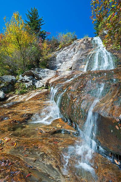
Upper Falls. (052C-110706)
Driving Directions
Open driving directions in map appThe three waterfalls in Graveyard Fields—Yellowstone Falls, Second Falls, Upper Falls— are accessed from Graveyard Fields Overlook on Blue Ridge Parkway, Milepost 418.9. The overlook is roughly halfway between US 276 and NC 215.
Hiking Directions
Quick Glance
Take the trail beginning at the upper end of the parking area. In a half mile you’ll cross the creek on a footbridge and then come to a T-junction. Turn left and follow the trail to the falls.
Detailed Look
Two trails start at the parking area and form Graveyard Fields Loop Trail. Upper Falls Trail turns off this loop. So, you can start the hike on one section of the loop trail and return by the other, making the hike a reverse lollipop. The trail down to the base of Second Falls also turns off this loop, making it easy to see both falls on the same hike.
Let’s begin at the upper end of the parking area. Take the steps, descend gradually through rhododendron tunnels, and come to a long footbridge over Yellowstone Prong in just under 0.5 miles. A short distance beyond the bridge is a T-junction. To the right is the continuation of the loop. Turn left and hike an easy 0.5 miles to a stream crossing. There are many side paths along the way, but if you pay attention you should be able to follow the main trail.
From the stream crossing, the trail begins ascending and is rocky and rooty. You’ll reach a fork at just over 0.4 miles from the stream. A left turn leads down to the creek well below the falls. Turn right and scramble up through the rocks to reach the base of the falls in just under 100 yards.
On the way back, when you get to the T near the footbridge, you can stay on the river-left side and finish the loop. You’ll come to a boardwalk in under 0.5 miles. Turn right, cross Yellowstone Prong on the footbridge above Second Falls, then follow the trail back to the parking area.
If you want to visit Second Falls, turn left at the boardwalk (don’t cross Yellowstone Prong) and then turn right when you come to a fork. The trail descends a long series of steps to the base of the falls.
| Accessibility: | Hiking trail |
| County: | Haywood |
| River Basin: | French Broad |
| Watercourse: | Yellowstone Prong of East Fork Pigeon River |
| Watershed: | Very small |
| Type and Height: | Steep, cascading slide about 45 feet high with a long series of cascades below Height estimated in field and from LiDAR map. |
| Landowner: | Pisgah NF, Pisgah RD |
| Beauty Rating: | 6 |
| Elevation: | 5320 feet |
| USGS Map: | Shining Rock |
| Hike Difficulty: | Moderate Class I bushwhack |
| Hike Distance: | 1.5 miles |
| Waterfall GPS: | 35.3181, -82.8654 |
| Parking GPS: | 35.320426, -83.846946 |