
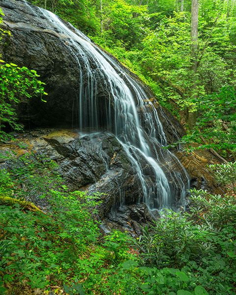
Upper Log Hollow Falls
!
During a healthy water flow, Upper Log Hollow Falls is pretty impressive. It’s hard to get a good view, though. You must be right at the base or the view is blocked by vegetation, and from up close, you can’t see the top portion of the falls.
(065Z2-122538)
Driving Directions
Open driving directions in map appFrom the junction of US 64, US 276, and NC 280 near Brevard, drive north on US 276 for 10.3 miles (passing Looking Glass Falls on the way) to the unpaved FS 475B (Headwaters Road), on the left. (From Blue Ridge Parkway, it is 4.7 miles to this point.) Drive 1.65 miles on FS 475B to a sharp left-hand curve. Park on the outside of the curve at the forest management interpretive sign.
FS 475B continues 4.9 miles to FS 475 near the old fish hatchery. It passes Slick Rock Falls and accesses for several other waterfalls on the way.
Hiking Directions
Quick Glance
FS 5043 begins at the outside of the curve and leads to Log Hollow Falls. From it, follow the path on the river-right side of the creek about 0.1 miles to the upper waterfall. This is the easiest access. See Detailed Look for info about accessing the falls from the river-left side.
Detailed Look
I’m giving directions here for ten waterfalls that are accessed from the same trailhead as Upper Log Hollow Falls:
- Log Hollow Falls
- Logging Road Falls
- Upper Log Hollow Falls
- Discovery Falls
- Upper Logging Road Falls
- Waterfall 1 on Log Hollow Branch
- Waterfall 2 on Log Hollow Branch
- Waterfall on Log Hollow Branch tributary
- Unseen waterfall above Logging Road Falls
- Upper Discovery Falls
Casual hikers will only want to visit the first two, perhaps adding numbers three and four. More hard-core waterfallers who don’t mind a little bushwhacking can see all these waterfalls on a single day hike.
Begin hiking at the gate on FS 5043, which begins on the outside of the curve. At 0.2 miles is a wide wooden bridge. Just before the bridge is a side path on the right that leads about 0.25 miles to Discovery Falls. Upper Discovery Falls is upstream a short distance, but I haven’t hiked to it and can’t give you any details.
Continuing FS 5043 from the bridge, it’s 0.3 miles to another bridge a short distance downstream from Log Hollow Falls. Just beyond the bridge is a side path leading a few feet up to the falls. Another path turns off it and ascends a little over 0.1 miles to Upper Log Hollow Falls. I haven’t hiked this path to the upper falls in several years and don’t know what kind of shape it’s currently in.
Back down at the bridge below Log Hollow Falls, if you continue FS 5043 it’s a little over 0.4 miles to Logging Road Falls, immediately upstream from the road.
To see Upper Logging Road Falls, you have a few choices. You can bushwhack upstream from FS 5043, which isn’t too bad as bushwhacks go (except for the first part along the falls) and will let you see another small waterfall that’s between the lower and upper falls. I haven’t seen it, but I know it’s there.
The easiest route to the upper falls, though certainly not the shortest, is to continue FS 5043 until it crosses Big Bearpen Branch. Shortly beyond the crossing, turn right on Seniard Ridge Trail and ascend to connect with an old forest road. Turn right on the road and follow it all the way to the stream at the upper falls. This route is shown on Gaia, where it is called Seniard Ridge Road. I haven’t hiked this way and can’t comment on the conditions you’ll encounter, but I suspect it’s pretty straightforward.
The route I took to Upper Logging Road Falls was to continue a quarter mile on FS 5043 from Logging Road Falls to a side path on the right that ascends the ridge beside the creek. The path begins shortly after the road makes the broad swing around the ridge. GPS reading for the start of the path is 35.320288, -82.811681. The path is obvious for about 250 yards, with the remainder being a Class I bushwhack. Except for the steepness, it’s pretty easy for an off-trail hike. The ridge is broad, but you shouldn’t have trouble remaining near the centerline. It’s a little over 0.3 miles from FS 5043 up to Seniard Ridge Road, a much shorter distance than the first route described above.
If climbing up the ridge, from the point where you reach the road it’s a little over 0.1 miles to the creek crossing above Upper Logging Road Falls. You can bushwhack down to the falls from there (river left is easiest), but the easier route is to drop off the road before you reach the creek. You can see the falls well from the road (in winter, at least) and from that point the bushwhack down to the base is not as tough as it is going down the river-left side.
From the creek crossing above Upper Logging Road Falls, it’s an easy 0.3-mile walk on the old forest road to Waterfall 1 on Log Hollow Branch. The road is now a bit overgrown but easily followed. A little over 0.1 miles from Upper Logging Road Falls the road swings left around a broad ridge. On the outside of the ridge a path turns off to the right. Be sure to remain on the road.
Nameless waterfall no. 1 on Log Hollow Branch is immediately upstream from the creek crossing, which is a washout. To see much of anything, you need to scramble up along the falls. A short distance up is Nameless waterfall on Log Hollow Branch tributary dropping in on the river-left side of Log Hollow Branch.
From the forest road crossing at Waterfall 1 on Log Hollow Branch, it’s less than 0.4 miles as the crow flies downstream to FS 5043 at Log Hollow Falls. Go down the river-left side. There is no trail, but the bushwhack is about as easy as an off-trail hike can be, and you’ll soon pick up an old logging grade that you can follow beside the creek for much of the way down.
The logging grade passes right beside Waterfall 2 on Log Hollow Branch, which you can view well from the grade, or you can climb down the steep slope to the base. A little farther down you’ll pass by Upper Log Hollow Falls. You can see it from the logging grade as well, but you don’t want to climb down the slope at that point. Instead, continue heading downstream to where another logging grade branches back to the right. It leads to the creek a short downstream from the falls, from which point it’s a much easier walk up to the falls than it would be climbing down the steep bank.
From Upper Log Hollow Falls, continue down the logging grade until it becomes indistinct. At this point, you’re close to FS 5043. Just head downhill until you reach it.
If you only want to see Upper Log Hollow Falls and the two waterfalls upstream, the best way to reach them would be to hike to the bridge below Log Hollow Falls. About 40 yards before the bridge there is what looks like the start of a path ascending the bank. Climb up it and bushwhack straight up through the open woods to pick up the logging grade and then follow it upstream to Upper Log Hollow Falls and Waterfall 2 on Log Hollow Branch, then continue the easy bushwhack up to Seniard Ridge Road at Waterfall 1 on Log Hollow Branch. If you can’t find the start of the path off FS 5043, just head up anywhere in the vicinity until you reach the logging grade. Even if you do find the path, it will disappear once you climb the steep bank by the road.
| Accessibility: | Forest road and hiking trail |
| County: | Transylvania |
| River Basin: | French Broad |
| Watercourse: | Log Hollow Branch |
| Watershed: | Small |
| Type and Height: | Sliding, cascading, and free-falling falls about 55 feet high Height estimated from LiDAR map. |
| Landowner: | Pisgah NF, Pisgah RD |
| Beauty Rating: | 6 |
| Elevation: | 3360 feet |
| USGS Map: | Shining Rock |
| Hike Difficulty: | Easy/moderate |
| Hike Distance: | About 0.6 miles |
| Waterfall GPS: | 35.32412, -82.80888 |
| Trailhead GPS: | 35.32641, -82.80176 |