Bee Branch Falls
!
Bee Branch Falls is among my favorite waterfall hikes in North Carolina, offering many rewards, including the gorgeous destination waterfall. It provides a great option for a long shuttle hike, so you don’t have to backtrack. And if you have bushwhacking experience, you can combine it with Upper Bee Branch Falls, another beautiful waterfall.
You can access the falls from Blue Ridge Parkway above or North Mills River area of Pisgah National Forest below. The hike from below passes right by Waterfall on Long Branch, then takes you to Hendersonville Reservoir Dam and Waterfall 1 on Fletcher Creek.
The Directions provide details on all the hiking options.
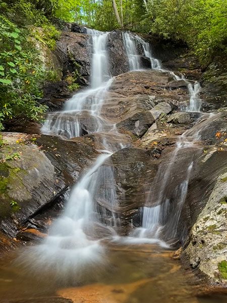
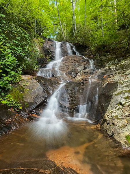
The middle section. (065Z1A-266953)
Driving Directions
Open driving directions in map appPisgah National Forest trailhead. From NC 280 in Mills River, turn on North Mills River Road and drive 4.9 miles to FS 5000 (Wash Creek Road) on the right, at North Mills River Recreation Area. Follow FS 5000 for 2.0 miles (becomes unpaved at 0.3 miles) and take the left fork onto FS 142. Drive 0.5 miles to Trace Ridge Trailhead at the end of the road.
Blue Ridge Parkway trailhead. The trail begins on the south end of Little Pisgah Ridge Tunnel, which is at Milepost 406.9 and approximately 1.7 miles north of Mount Pisgah Inn.
Shuttle info. My favorite way to hike to the falls and the upper one is a shuttle hike, leaving a car at the lower trailhead and starting the hike from Blue Ridge Parkway (at my age, I prefer hiking downhill whenever possible). After leaving a car at the lower trailhead, the quickest way to reach the upper trailhead is to drive back on FS 142 to FS 5000 but don’t turn right on go back to North Mills Recreation Area. Instead, make a sharp left turn and drive 3.75 miles to Blue Ridge Parkway. Turn left on the parkway and drive south to the trailhead.
Hiking Directions
Quick Glance
Ain’t nothing quick about this one!
Detailed Look
I’m describing the hike from both trailheads and including Upper Bee Branch Falls.
From Trace Ridge Trailhead in Pisgah National Forest. Two gated forest roads, close together, begin from the trailhead. FS 5097 is on the right and the continuation of FS 142 is to the left. Take FS 142 and hike 1.6 miles to Hendersonville Reservoir. (Along the way you’ll pass by Waterfall on Long Branch.)
At the lake, take the trail to the right that leads a short distance to the top of Waterfall 1 on Fletcher Creek. Cross the creek and begin hiking Big Creek Trail. You’ll follow the trail for about 2.5 miles, making four crossings of Big Creek, plus a few braid crossings. All should be relatively easy during normal flows.
A quarter mile from the fourth crossing is the Bee Branch crossing. The crossing is nondescript, but it doesn’t really matter if you miss it because you don’t want to cross, anyway. You want to follow Bee Branch upstream on the river-left side to the waterfall. From the trail crossing, you’ll be able to follow an old logging grade for a little bit before it becomes a Class I bushwhack. It’s roughly 0.2 miles up to the falls.
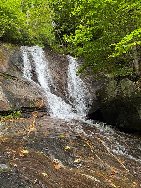
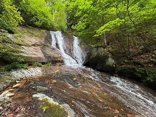
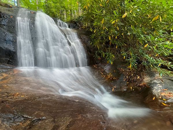
When you reach the falls, you’ll see only the lower section. To view the middle and upper sections, you must bushwhack up the slope, with the river-left side probably easiest. This is a much more difficult bushwhack, but you definitely should see at least the middle section. It wouldn’t be a big deal to miss the upper part, but if you’re continuing to Upper Bee Branch Falls, you’ll see it anyway.
For Upper Bee Branch Falls, you’ll just continue following the creek upstream. It’s less than 0.2 miles from the top of Bee Branch Falls. The woods are nicely open for bushwhacking, but it’s very steep. Along the way you’ll pass a nice little cascade. If you’re hiking in late summer/early autumn, look out for the deep purple flowers of monkshood, a relatively rare plant that grows here.
From the trailhead at Blue Ridge Parkway. Big Creek Trail begins right at the south entrance of the tunnel. You’ll ascend gently and then descend. At 0.2 miles, the trail swings right, while an old road swings left. This road is the bypass road that was used while the tunnel was constructed. You hiked on part of it to get here.
Now the trail begins a steep descent down Little Pisgah Ridge. It follows the ridge closely, using lots of switchbacks. The easiest way to reach Bee Branch Falls is to follow the trail all the way down to the crossing of Bee Branch, then follow Bee Branch upstream on the river-left side to the falls. From Blue Ridge Parkway to the Bee Branch crossing is about 2.1 miles, with an elevation loss of about 1,900 feet.
If you’re planning to see Upper Bee Branch Falls, an easier option is to turn off Big Creek Trail and bushwhack over to the upper falls, then follow the creek downstream to the lower falls and continue down to Big Creek Trail from there. This is the route I like to take.
I don’t know the best spot from which to leave the trail for the upper falls, but the route I took was relatively easy as bushwhacks go. The point I left the trail was 35.42014, -82.72334. It was at an elevation of about 3,500 feet. I climbed up and over a small ridge, then a larger one, then a smaller one. If you follow a direct route to the falls from this GPS point, you’ll hike through mostly open woods on a Class II bushwhack.
| Accessibility: | Forest road, trail, bushwhack |
| County: | Henderson |
| River Basin: | French Broad |
| Watercourse: | Bee Branch |
| Watershed: | Small |
| Type and Height: | Multilevel falls, 145 feet high Height measured with rangefinder. |
| Landowner: | Pisgah NF, Pisgah RD |
| Beauty Rating: | 8 |
| Elevation: | 3120 feet |
| USGS Map: | Dunsmore Mountain |
| Hike Difficulty: | Difficult |
| Hike Distance: | Approx. 4.3 miles from PNF trailhead and 2.3 miles from BRP trailhead |
| Waterfall GPS: | 35.42087, -82.717147 Reading taken from a few yards upstream of the base. |
| Trailhead GPS 1 & 2: | 35.42028, -82.65683 This is for the Pisgah National Forest trailhead. This is for the Blue Ridge Parkway trailhead. |
Photo Gallery
Click a photo to enlarge.