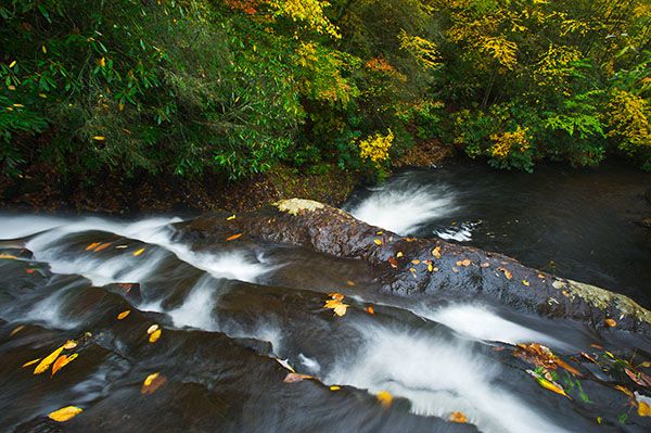
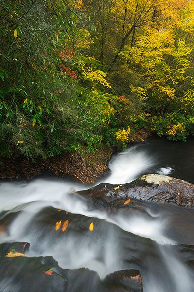
Lower Balsam Falls
!
As the name implies, Lower Balsam Falls is downstream from Balsam Falls. When you view Balsam, you’re standing at the brink of Lower. Fortunately, you no longer have to cross the creek at the top of the falls to reach the base.
You’ll pass by Balsam Lake Dam on the way to the falls, the lake and dam providing a nice bonus for the hike.
Downstream are the highly scenic Patricia Falls and Lauren Falls. Since many people who come here also visit these other falls on the same hike, I’m giving info for all the falls in Hiking Directions, plus a little bit for the two waterfalls on a side stream below Lauren Falls.

(028C2-48662)
Driving Directions
Open driving directions in map appThe trailhead is at Balsam Lake Recreation Area on Charleys Creek Road (SR 1756). From the east, turn off NC 215 onto Charleys Creek Road, 3.2 miles south of Blue Ridge Parkway. Follow Charleys Creek Road 5.3 miles to Balsam Lake. From the west, you can access Charleys Creek Road from NC 281, some 8.4 miles south of NC 107. From that direction, it is 5.4 miles to Balsam Lake.
The trailhead is the same for Balsam Lake Dam, Balsam Falls, Patricia Falls, and Lauren Falls.
Hiking Directions
The Detailed Look section provides directions for all four waterfalls in this section of Wolf Creek, plus info for two waterfalls on a side stream.
Quick Glance
Cross Wolf Creek on the footbridge and follow the trail to the dam. Hike the path heading downstream from the dam to Balsam Falls, then continue on the path to Lower Balsam Falls.
Detailed Look
Cross Wolf Creek on the footbridge and follow the trail to the dam. Right at the dam is an obvious, but unofficial path heading downstream. It’s not graded but easy to follow. When you reach Balsam Falls, you’ll see the short, steep scramble path to the base. Be careful, especially if you wade out into the pool.
The old route to the lower waterfalls required wading across the pool below Balsam Falls, which is right at the brink of Lower Balsam Falls. Thankfully, there is now a much better route, created by enough waterfallers who didn’t relish the wade. After viewing Balsam Falls, climb back up to the path and continue following it downstream.
his part of the path is a little difficult, but at least it’s not a bushwhack. It comes out at the downstream end of the pool below Lower Balsam Falls. You must cross the creek here, but this is a piece of cake compared to crossing above the falls. You’ll probably want to find a spot a few feet downstream from where the path comes to the creek.
There is a tiny island here that has two medium-size trees growing on it. Walk to the upstream end of the island, hop across the tiny channel, and climb up the bank. It looks sketchy, but shouldn’t be a problem if you’ve made it this far. The rough path ascends steeply to meet the old path coming down from Balsam Falls. Head downstream on it.
The path is overgrown in places but if you follow the route of least resistance, you should be able to remain on it. If not, no worries. Just head downstream and work your way to the creek. The path does just that and then follows closely along the creek.
After crossing a small side stream, look for a good place to cross Wolf Creek. The brink of Patricia Falls is just around the bend and a ridge comes down to the creek on the other (river-left) side. The old route to the base required hiking up a short distance on the ridge, then turning to the right and descending a hellish route on the steep rock face. Fortunately, there’s now a better way.
After crossing the creek, look for a path that climbs up the bank and heads up the ridge. You’ll quickly come to the old route that turns right. Keep going straight and follow the relatively new route that circles above the hellhole before dropping down to the falls. It’s not easy by any definition, but at least it’s not suicidal.
Lauren Falls is only a few yards downstream from Patricia. The old route to it competed with the old route to Patricia for the most “This can’t be right” comments from hikers. But sometime between 2019 and 2025, someone built a new trail between the two falls. It’s a decent trail, with cut trees, stone steps, and grading. Imagine my delight in finding this!
When you get close to Lauren Falls, a side path turns to the right and deposits you at the base of the falls. For the best view, you’ll want to cross the river-left division of the creek to get to the little island and walk up to the edge of the pool.
The main trail continues following Wolf Creek downstream. Where it ends up, I do not yet know.
Waterfalls on Unnamed Tributary Below Lauren Falls
An unnamed tributary enters the river-right side of Wolf Creek a short distance downstream from Lauren Falls. Upstream on it are two waterfalls, one well over 100 feet high. It’s a very small stream and the bushwhack to them is horrid. I’ve no intention of ever hiking to these waterfalls again!
I provide detailed information for them on their dedicated pages: Lower waterfall on Wolf Creek tributary below Lauren Falls, and Upper waterfall on Wolf Creek tributary below Lauren Falls. Basically, you can hike in from above off Charleys Creek Road, or from below. If hiking from below, you would follow the trail downstream to a little river-wide waterfall on Wolf Creek. The tributary is a short distance upstream from this little falls, on the opposite (river-right) side of the creek.
| Accessibility: | Hiking trail |
| County: | Jackson |
| River Basin: | Little Tennessee |
| Watercourse: | Wolf Creek |
| Watershed: | Small/medium |
| Type and Height: | Steep, cascading falls, 22 feet high Height measured with rangefinder. |
| Landowner: | Nantahala NF, Nantahala RD |
| Beauty Rating: | 6 |
| Elevation: | 3460 feet |
| USGS Map: | Sam Knob |
| Hike Difficulty: | Difficult |
| Hike Distance: | A little over 0.6 miles |
| Waterfall GPS: | 35.26578, -82.96934 |
| Trailhead GPS: | 35.272925, -82.969369 |
Photo Gallery
Click a photo to enlarge.