Cody Falls
!
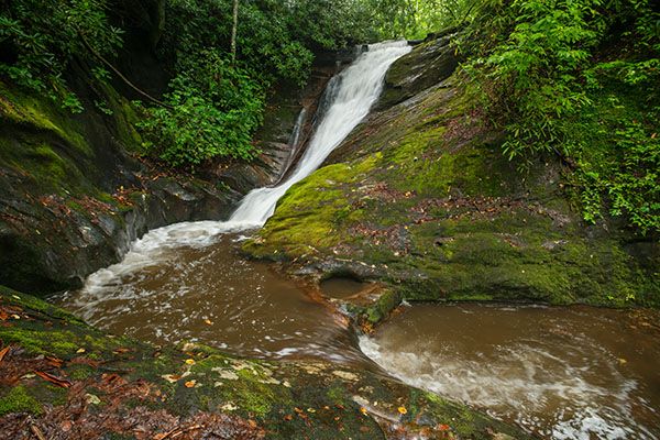
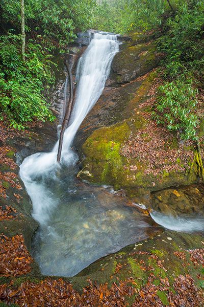
Cody Falls is similar to Courthouse Falls but smaller. It slides down a steep rock face into a little pool carved out of solid rock. All the rocks around the falls are covered in moss. The climb down to the base is steep, but it’s definitely worth it for those who don’t mind a little more challenging path. And you’re likely to have the waterfall mostly to yourself.
(022J-115245)
Driving Directions
Open driving directions in map appThe trailhead is the same as Courthouse Falls and the falls upstream on Courthouse Creek, and the waterfalls on Chestnut Creek. From Beech Gap on Blue Ridge Parkway, drive 6.65 miles south on NC 215 and turn left on the gravel FS 140 (Courthouse Creek Road). FS 140 is 10.4 miles north of US 64. Follow the road for 2.5 miles to the gate and park in the cleared area on the left. This trailhead is 0.2 miles farther on FS 140 than the trailhead for Kiesee Falls and Upper Kiesee Falls.
Note that as of this writing, FS 140 is closed indefinitely. If it is closed when you visit, you’ll have to park in the area beside NC 215, across from FS 140, and walk the road.
Hiking Directions
The first 0.8 mile is the same as the hike to Courthouse Falls.
Quick Glance
From the gate on FS 140, follow the road 0.5 miles to the bridge over Courthouse Creek. Hike the trail that follows the creek downstream for 0.3 miles and take the side path on the left. In a short distance, take another side path on the right that descends to Mill Station Creek, a short distance downstream from Cody Falls.
Detailed Look
Hike or drive FS 140 for 2.5 miles to the gate, then continue another 0.5 miles to the bridge over Courthouse Creek. (You'll pass FS 5031, 0.1 mile from the gate. This is the access for Chestnut Falls and the waterfalls downstream from it.) Summey Cove Trail begins immediately beyond the bridge and follows the creek downstream. Follow it 0.3 miles to where it starts swinging to the right. An obvious side path is here on the left. This path descends to the base of Courthouse Falls. For Cody Falls, take the side path that turns right off this path, 70 feet from Summey Cove Trail. This path descends steeply to Mill Station Creek, a few yards downstream from the falls. Walk in the creekbed up to the base of the falls.
| Accessibility: | Hiking trail |
| County: | Transylvania |
| River Basin: | French Broad |
| Watercourse: | Mill Station Creek |
| Watershed: | Small |
| Type and Height: | Steep sliding falls about 22 feet high Height estimated. |
| Landowner: | Pisgah NF, Pisgah RD |
| Beauty Rating: | 6 |
| Elevation: | 3360 feet |
| USGS Map: | Sam Knob |
| Hike Difficulty: | Easy/difficult |
| Hike Distance: | Approx. 0.9 miles |
| Waterfall GPS: | 35.270905, -82.895343 |
| Trailhead GPS: | 35.269447, -83.8891 |
Photo Gallery
Click a photo to enlarge.